Calvatone geodata
Calvatone (Lombardy) is a seat of a third-order administrative division; located in Italy in Europe/Rome (GMT+2) time zone. With population of 1,211 people, there are 5920 cities with bigger population in this country. Compared to other cities in Italy, 63.1% of cities are located further ↓South; 63.5% of cities are located further →East and 86.1% of cities have higher elevation than Calvatone. Note1


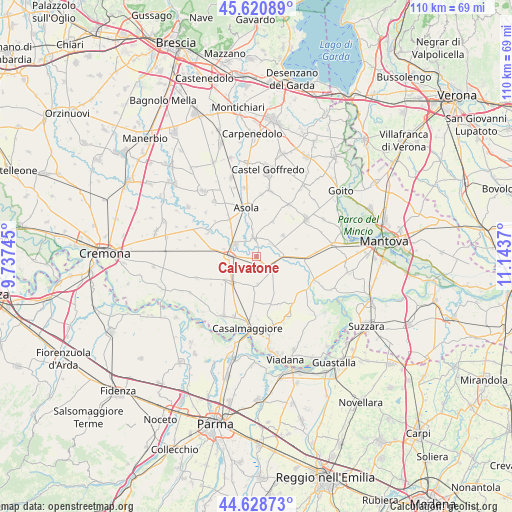
Calvatone GPS coordinates[2]
45° 7' 37.092" North, 10° 26' 26.052" East
| Map corner | latitude | longitude |
|---|---|---|
| Upper-left | 45.62089°, | 9.73745° |
| Center: | 45.12697°, | 10.44057° |
| Lower-right: | 44.62873°, | 11.1437° |
| Map W x H: | 110.3×110.3 km | = 68.5×68.5mi |
| max Lat: | 47.04031° ⇑36.9% North |
| Calvatone: | 45.12697° |
| min Lat: | ⇓63.1% South 35.50142° |
| min Long | Calvatone | max Long |
| 6.69888° | 10.44057° | 18.48682° |
| W 36.5%⇐ | ⇒63.5% E |
Elevation
Elevation of Calvatone is 28 m = 92 ft, and this is 278.7 m = 914 ft below average elevation for this country.
| Max E: |
2085 m = 6841 ft | 86.1% |
| Avg. | 306.7 m = 1006 ft | |
| Calvatone | 28 m = 92 ft | |
Min E: |
-4 m = -13 ft | 13.9% |
See also: Italy elevation on elevation.city.
Geographical zone
Calvatone is located in North temperate zone (between Tropic of Cancer and the Arctic Circle). Distance of this North polar circle is 2383.5 km =1481 mi to North.| Distance of | km | miles | from Calvatone |
|---|---|---|---|
| North Pole | 4989.4 | 3100.3 | to North |
| Arctic Circle | 2383.5 | 1481 | to North |
| Tropic Cancer | 2411.7 | 1498.6 | to South |
| Equator | 5017.6 | 3117.8 | to South |


Nearby cities:
15 places around Calvatone: (largest is in red/bold)
• Acquanegra sul Chiese
4.2 km =2.6 mi,  352°
352°
• Bozzolo
4.1 km =2.5 mi,  130°
130°
• Canneto sull'Oglio
5.3 km =3.3 mi,  301°
301°
• Casteldidone
6.8 km =4.2 mi,  203°
203°
• Drizzona
7.3 km =4.5 mi,  283°
283°
• Marcaria
7.3 km =4.5 mi,  94°
94°
• Mariana Mantovana
8.2 km =5.1 mi,  26°
26°
• Piadena
5.5 km =3.4 mi,  271°
271°
• Redondesco
7.1 km =4.4 mi,  52°
52°
• Rivarolo Mantovano
6 km =3.7 mi,  182°
182°
• San Giovanni in Croce
7.9 km =4.9 mi,  221°
221°
• San Martino Dall'Argine
6.9 km =4.3 mi,  118°
118°
• Solarolo Rainerio
8.3 km =5.2 mi,  232°
232°
• Tornata
2.6 km =1.6 mi, 196°
• Voltido
8.6 km =5.3 mi,  258°
258°
Sources, notices
• [Note1] Compared only with cities in Italy existing in our database
• [Src1] Map data: © OpenStreetMap contributors (CC-BY-SA)
• [Src2] Other city data from geonames.org with taken over terms of usage.
• [Src3] Geographical zone / Annual Mean Temperature by Robert A. Rohde @ Wikipedia
