Tornata geodata
Tornata (Lombardy) is a seat of a third-order administrative division; located in Italy in Europe/Rome (GMT+2) time zone. With population of 222 people, there are 11021 cities with bigger population in this country. Compared to other cities in Italy, 62.5% of cities are located further ↓South; 63.6% of cities are located further →East and 85.6% of cities have higher elevation than Tornata. Note1


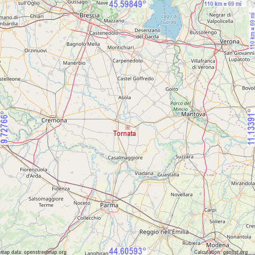
Tornata GPS coordinates[2]
45° 6' 15.732" North, 10° 25' 50.808" East
| Map corner | latitude | longitude |
|---|---|---|
| Upper-left | 45.59849°, | 9.72766° |
| Center: | 45.10437°, | 10.43078° |
| Lower-right: | 44.60593°, | 11.13391° |
| Map W x H: | 110.4×110.4 km | = 68.6×68.6mi |
| max Lat: | 47.04031° ⇑37.5% North |
| Tornata: | 45.10437° |
| min Lat: | ⇓62.5% South 35.50142° |
| min Long | Tornata | max Long |
| 6.69888° | 10.43078° | 18.48682° |
| W 36.4%⇐ | ⇒63.6% E |
Elevation
Elevation of Tornata is 29 m = 95 ft, and this is 277.7 m = 911 ft below average elevation for this country.
| Max E: |
2085 m = 6841 ft | 85.6% |
| Avg. | 306.7 m = 1006 ft | |
| Tornata | 29 m = 95 ft | |
Min E: |
-4 m = -13 ft | 14.4% |
See also: Italy elevation on elevation.city.
Geographical zone
Tornata is located in North temperate zone (between Tropic of Cancer and the Arctic Circle). Distance of this North polar circle is 2386 km =1482.6 mi to North.| Distance of | km | miles | from Tornata |
|---|---|---|---|
| North Pole | 4991.9 | 3101.8 | to North |
| Arctic Circle | 2386 | 1482.6 | to North |
| Tropic Cancer | 2409.2 | 1497 | to South |
| Equator | 5015.1 | 3116.2 | to South |


Nearby cities:
15 places around Tornata: (largest is in red/bold)
• Acquanegra sul Chiese
6.6 km =4.1 mi,  1°
1°
• Bozzolo
3.9 km =2.4 mi,  91°
91°
• Calvatone
2.6 km =1.6 mi,  16°
16°
• Canneto sull'Oglio
6.5 km =4 mi,  324°
324°
• Casteldidone
4.2 km =2.6 mi,  207°
207°
• Drizzona
7.6 km =4.7 mi,  303°
303°
• Marcaria
8.2 km =5.1 mi,  76°
76°
• Piadena
5.4 km =3.4 mi, 299°
• Rivarolo Mantovano
3.6 km =2.2 mi,  171°
171°
• Rivarolo del Re
8.8 km =5.5 mi,  158°
158°
• San Giovanni in Croce
5.6 km =3.5 mi,  233°
233°
• San Martino Dall'Argine
6.9 km =4.3 mi,  96°
96°
• Solarolo Rainerio
6.3 km =3.9 mi,  246°
246°
• Spineda
7.9 km =4.9 mi,  126°
126°
• Voltido
7.7 km =4.8 mi,  276°
276°
Sources, notices
• [Note1] Compared only with cities in Italy existing in our database
• [Src1] Map data: © OpenStreetMap contributors (CC-BY-SA)
• [Src2] Other city data from geonames.org with taken over terms of usage.
• [Src3] Geographical zone / Annual Mean Temperature by Robert A. Rohde @ Wikipedia
