Annunziata geodata
Annunziata (Campania) is a seat of a third-order administrative division; located in Italy in Europe/Rome (GMT+2) time zone. With population of 3,596 people, there are 2627 cities with bigger population in this country. Compared to other cities in Italy, 77.4% of cities are located further ↑North; 81.4% of cities are located further ←West and 51.9% of cities have lower elevation than Annunziata. Note1


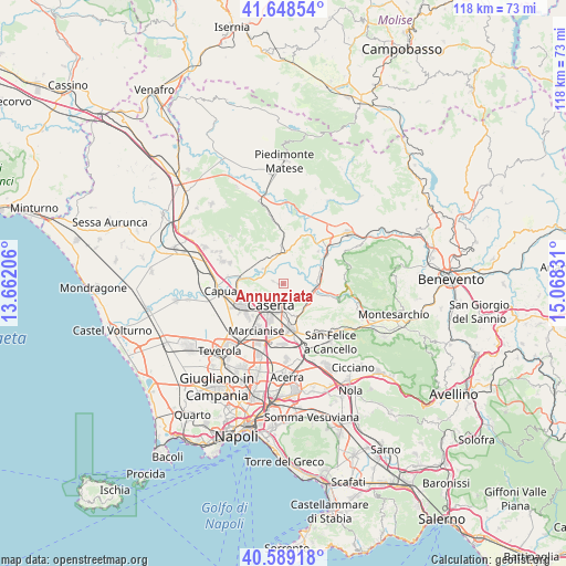
Annunziata GPS coordinates[2]
41° 7' 15.6" North, 14° 21' 54.648" East
| Map corner | latitude | longitude |
|---|---|---|
| Upper-left | 41.64854°, | 13.66206° |
| Center: | 41.121°, | 14.36518° |
| Lower-right: | 40.58918°, | 15.06831° |
| Map W x H: | 117.8×117.8 km | = 73.2×73.2mi |
| max Lat: | 47.04031° ⇑77.4% North |
| Annunziata: | 41.121° |
| min Lat: | ⇓22.6% South 35.50142° |
| min Long | Annunziata | max Long |
| 6.69888° | 14.36518° | 18.48682° |
| W 81.4%⇐ | ⇒18.6% E |
Elevation
Elevation of Annunziata is 246 m = 807 ft, and this is 60.7 m = 199 ft below average elevation for this country.
| Max E: |
2085 m = 6841 ft | 48.1% |
| Avg. | 306.7 m = 1006 ft | |
| Annunziata | 246 m = 807 ft | |
Min E: |
-4 m = -13 ft | 51.9% |
See also: Italy elevation on elevation.city.
Geographical zone
Annunziata is located in North temperate zone (between Tropic of Cancer and the Arctic Circle). Distance of this Northern Tropic circle is 1966.3 km =1221.8 mi to South.| Distance of | km | miles | from Annunziata |
|---|---|---|---|
| North Pole | 5434.8 | 3377 | to North |
| Arctic Circle | 2828.9 | 1757.8 | to North |
| Tropic Cancer | 1966.3 | 1221.8 | to South |
| Equator | 4572.2 | 2841 | to South |


Nearby cities:
15 places around Annunziata: (largest is in red/bold)
• Bagnoli
7.6 km =4.7 mi,  124°
124°
• Caiazzo
7.1 km =4.4 mi,  356°
356°
• Casagiove
7.1 km =4.4 mi,  219°
219°
• Casapulla
8 km =5 mi,  232°
232°
• Caserta
6 km =3.7 mi,  207°
207°
• Casola
3.2 km =2 mi,  154°
154°
• Castel Morrone
0.9 km =0.6 mi,  270°
270°
• Dugenta
7.6 km =4.7 mi,  78°
78°
• Giardoni
5.4 km =3.4 mi,  92°
92°
• Limatola
3.2 km =2 mi,  48°
48°
• Piana di Monte Verna
5.8 km =3.6 mi,  332°
332°
• San Giovanni e Paolo
6.4 km =4 mi,  17°
17°
• San Nicola la Strada
8.1 km =5 mi,  199°
199°
• San Prisco
8.4 km =5.2 mi,  242°
242°
• Valle di Maddaloni
6.4 km =4 mi,  136°
136°
Sources, notices
• [Note1] Compared only with cities in Italy existing in our database
• [Src1] Map data: © OpenStreetMap contributors (CC-BY-SA)
• [Src2] Other city data from geonames.org with taken over terms of usage.
• [Src3] Geographical zone / Annual Mean Temperature by Robert A. Rohde @ Wikipedia
