Gambara geodata
Gambara (Lombardy) is a seat of a third-order administrative division; located in Italy in Europe/Rome (GMT+2) time zone. With population of 4,099 people, there are 2344 cities with bigger population in this country. Compared to other cities in Italy, 66.3% of cities are located further ↓South; 65.1% of cities are located further →East and 80.3% of cities have higher elevation than Gambara. Note1


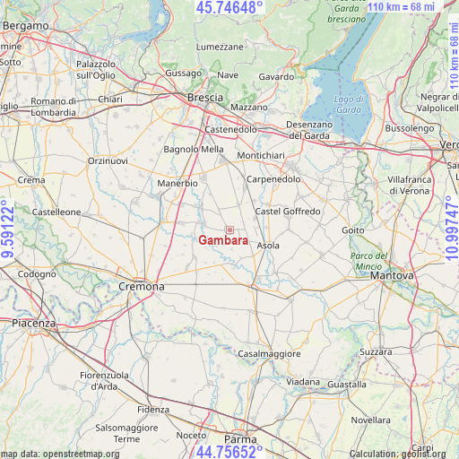
Gambara GPS coordinates[2]
45° 15' 13.176" North, 10° 17' 39.624" East
| Map corner | latitude | longitude |
|---|---|---|
| Upper-left | 45.74648°, | 9.59122° |
| Center: | 45.25366°, | 10.29434° |
| Lower-right: | 44.75652°, | 10.99747° |
| Map W x H: | 110.1×110.1 km | = 68.4×68.4mi |
| max Lat: | 47.04031° ⇑33.7% North |
| Gambara: | 45.25366° |
| min Lat: | ⇓66.3% South 35.50142° |
| min Long | Gambara | max Long |
| 6.69888° | 10.29434° | 18.48682° |
| W 34.9%⇐ | ⇒65.1% E |
Elevation
Elevation of Gambara is 48 m = 157 ft, and this is 258.7 m = 849 ft below average elevation for this country.
| Max E: |
2085 m = 6841 ft | 80.3% |
| Avg. | 306.7 m = 1006 ft | |
| Gambara | 48 m = 157 ft | |
Min E: |
-4 m = -13 ft | 19.7% |
See also: Italy elevation on elevation.city.
Geographical zone
Gambara is located in North temperate zone (between Tropic of Cancer and the Arctic Circle). Distance of this North polar circle is 2369.4 km =1472.3 mi to North.| Distance of | km | miles | from Gambara |
|---|---|---|---|
| North Pole | 4975.3 | 3091.5 | to North |
| Arctic Circle | 2369.4 | 1472.3 | to North |
| Tropic Cancer | 2425.8 | 1507.3 | to South |
| Equator | 5031.7 | 3126.6 | to South |


Nearby cities:
15 places around Gambara: (largest is in red/bold)
• Casalromano
8.4 km =5.2 mi,  137°
137°
• Fiesse
3.3 km =2.1 mi, 135°
• Gabbioneta
7.1 km =4.4 mi,  234°
234°
• Gottolengo
4.8 km =3 mi,  335°
335°
• Isola Dovarese
9 km =5.6 mi,  172°
172°
• Isorella
6.6 km =4.1 mi,  19°
19°
• Milzano
7.8 km =4.8 mi,  286°
286°
• Ostiano
4.7 km =2.9 mi,  222°
222°
• Pavone del Mella
8.5 km =5.3 mi,  308°
308°
• Pessina Cremonese
8.4 km =5.2 mi,  205°
205°
• Pralboino
6.1 km =3.8 mi,  284°
284°
• Remedello
6.7 km =4.2 mi,  65°
65°
• Remedello di Sopra
6.6 km =4.1 mi, 65°
• Remedello di Sotto
6.8 km =4.2 mi,  84°
84°
• Volongo
4.7 km =2.9 mi, 172°
Sources, notices
• [Note1] Compared only with cities in Italy existing in our database
• [Src1] Map data: © OpenStreetMap contributors (CC-BY-SA)
• [Src2] Other city data from geonames.org with taken over terms of usage.
• [Src3] Geographical zone / Annual Mean Temperature by Robert A. Rohde @ Wikipedia
