Fiesse geodata
Fiesse (Lombardy) is a seat of a third-order administrative division; located in Italy in Europe/Rome (GMT+2) time zone. With population of 1,585 people, there are 4933 cities with bigger population in this country. Compared to other cities in Italy, 65.7% of cities are located further ↓South; 64.8% of cities are located further →East and 82.2% of cities have higher elevation than Fiesse. Note1


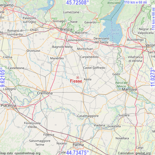
Fiesse GPS coordinates[2]
45° 13' 55.452" North, 10° 19' 27.012" East
| Map corner | latitude | longitude |
|---|---|---|
| Upper-left | 45.72508°, | 9.62105° |
| Center: | 45.23207°, | 10.32417° |
| Lower-right: | 44.73475°, | 11.0273° |
| Map W x H: | 110.1×110.1 km | = 68.4×68.4mi |
| max Lat: | 47.04031° ⇑34.3% North |
| Fiesse: | 45.23207° |
| min Lat: | ⇓65.7% South 35.50142° |
| min Long | Fiesse | max Long |
| 6.69888° | 10.32417° | 18.48682° |
| W 35.2%⇐ | ⇒64.8% E |
Elevation
Elevation of Fiesse is 41 m = 135 ft, and this is 265.7 m = 872 ft below average elevation for this country.
| Max E: |
2085 m = 6841 ft | 82.2% |
| Avg. | 306.7 m = 1006 ft | |
| Fiesse | 41 m = 135 ft | |
Min E: |
-4 m = -13 ft | 17.8% |
See also: Italy elevation on elevation.city.
Geographical zone
Fiesse is located in North temperate zone (between Tropic of Cancer and the Arctic Circle). Distance of this North polar circle is 2371.8 km =1473.8 mi to North.| Distance of | km | miles | from Fiesse |
|---|---|---|---|
| North Pole | 4977.7 | 3093 | to North |
| Arctic Circle | 2371.8 | 1473.8 | to North |
| Tropic Cancer | 2423.4 | 1505.8 | to South |
| Equator | 5029.3 | 3125.1 | to South |


Nearby cities:
15 places around Fiesse: (largest is in red/bold)
• Asola
7 km =4.3 mi,  100°
100°
• Casalmoro
7.5 km =4.7 mi,  64°
64°
• Casalromano
5 km =3.1 mi,  138°
138°
• Gabbioneta
8.3 km =5.2 mi,  257°
257°
• Gambara
3.3 km =2.1 mi,  315°
315°
• Gottolengo
8 km =5 mi,  327°
327°
• Isola Dovarese
6.7 km =4.2 mi,  190°
190°
• Isorella
8.6 km =5.3 mi,  359°
359°
• Ostiano
5.6 km =3.5 mi, 259°
• Pessina Cremonese
7.9 km =4.9 mi,  228°
228°
• Pralboino
9.2 km =5.7 mi,  295°
295°
• Remedello
6.4 km =4 mi,  36°
36°
• Remedello di Sopra
6.4 km =4 mi, 35°
• Remedello di Sotto
5.4 km =3.4 mi,  54°
54°
• Volongo
2.8 km =1.7 mi,  216°
216°
Sources, notices
• [Note1] Compared only with cities in Italy existing in our database
• [Src1] Map data: © OpenStreetMap contributors (CC-BY-SA)
• [Src2] Other city data from geonames.org with taken over terms of usage.
• [Src3] Geographical zone / Annual Mean Temperature by Robert A. Rohde @ Wikipedia
