Drizzona geodata
Drizzona (Lombardy) is a seat of a third-order administrative division; located in Italy in Europe/Rome (GMT+2) time zone. With population of 371 people, there are 10388 cities with bigger population in this country. Compared to other cities in Italy, 63.5% of cities are located further ↓South; 64.5% of cities are located further →East and 85% of cities have higher elevation than Drizzona. Note1
Administrative division(s):
- Level 1: Lombardy
- Level 2: Provincia di Cremona
- Level 3: Piadena Drizzona


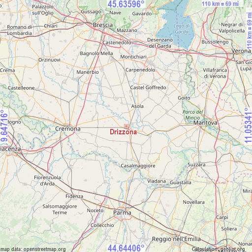
Drizzona GPS coordinates[2]
45° 8' 31.812" North, 10° 21' 1.008" East
| Map corner | latitude | longitude |
|---|---|---|
| Upper-left | 45.63596°, | 9.64716° |
| Center: | 45.14217°, | 10.35028° |
| Lower-right: | 44.64406°, | 11.05341° |
| Map W x H: | 110.3×110.3 km | = 68.5×68.5mi |
| max Lat: | 47.04031° ⇑36.5% North |
| Drizzona: | 45.14217° |
| min Lat: | ⇓63.5% South 35.50142° |
| min Long | Drizzona | max Long |
| 6.69888° | 10.35028° | 18.48682° |
| W 35.5%⇐ | ⇒64.5% E |
Elevation
Elevation of Drizzona is 31 m = 102 ft, and this is 275.7 m = 905 ft below average elevation for this country.
| Max E: |
2085 m = 6841 ft | 85% |
| Avg. | 306.7 m = 1006 ft | |
| Drizzona | 31 m = 102 ft | |
Min E: |
-4 m = -13 ft | 15% |
See also: Italy elevation on elevation.city.
Geographical zone
Drizzona is located in North temperate zone (between Tropic of Cancer and the Arctic Circle). Distance of this North polar circle is 2381.8 km =1480 mi to North.| Distance of | km | miles | from Drizzona |
|---|---|---|---|
| North Pole | 4987.7 | 3099.2 | to North |
| Arctic Circle | 2381.8 | 1480 | to North |
| Tropic Cancer | 2413.4 | 1499.6 | to South |
| Equator | 5019.3 | 3118.8 | to South |


Nearby cities:
15 places around Drizzona: (largest is in red/bold)
• Acquanegra sul Chiese
6.9 km =4.3 mi,  69°
69°
• Ca' d'Andrea
6.2 km =3.9 mi,  246°
246°
• Calvatone
7.3 km =4.5 mi,  103°
103°
• Canneto sull'Oglio
2.8 km =1.7 mi, 67°
• Casalromano
6.3 km =3.9 mi,  11°
11°
• Cingia de' Botti
8.6 km =5.3 mi,  222°
222°
• Isola Dovarese
4.7 km =2.9 mi,  316°
316°
• Piadena
2.2 km =1.4 mi,  132°
132°
• San Giovanni in Croce
7.8 km =4.8 mi,  166°
166°
• San Martino del Lago
8.2 km =5.1 mi,  199°
199°
• Solarolo Rainerio
6.8 km =4.2 mi,  175°
175°
• Tornata
7.6 km =4.7 mi,  123°
123°
• Torre de' Picenardi
4.9 km =3 mi,  271°
271°
• Volongo
8.6 km =5.3 mi,  334°
334°
• Voltido
3.6 km =2.2 mi, 202°
Sources, notices
• [Note1] Compared only with cities in Italy existing in our database
• [Src1] Map data: © OpenStreetMap contributors (CC-BY-SA)
• [Src2] Other city data from geonames.org with taken over terms of usage.
• [Src3] Geographical zone / Annual Mean Temperature by Robert A. Rohde @ Wikipedia
