Carinola geodata
Carinola (Campania) is a seat of a third-order administrative division; located in Italy in Europe/Rome (GMT+2) time zone. With population of 1,198 people, there are 5966 cities with bigger population in this country. Compared to other cities in Italy, 77% of cities are located further ↑North; 78.1% of cities are located further ←West and 75.4% of cities have higher elevation than Carinola. Note1


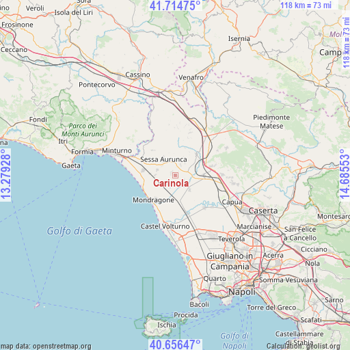
Carinola GPS coordinates[2]
41° 11' 15.9" North, 13° 58' 56.64" East
| Map corner | latitude | longitude |
|---|---|---|
| Upper-left | 41.71475°, | 13.27928° |
| Center: | 41.18775°, | 13.9824° |
| Lower-right: | 40.65647°, | 14.68553° |
| Map W x H: | 117.7×117.7 km | = 73.1×73.1mi |
| max Lat: | 47.04031° ⇑77% North |
| Carinola: | 41.18775° |
| min Lat: | ⇓23% South 35.50142° |
| min Long | Carinola | max Long |
| 6.69888° | 13.9824° | 18.48682° |
| W 78.1%⇐ | ⇒21.9% E |
Elevation
Elevation of Carinola is 72 m = 236 ft, and this is 234.7 m = 770 ft below average elevation for this country.
| Max E: |
2085 m = 6841 ft | 75.4% |
| Avg. | 306.7 m = 1006 ft | |
| Carinola | 72 m = 236 ft | |
Min E: |
-4 m = -13 ft | 24.6% |
See also: Italy elevation on elevation.city.
Geographical zone
Carinola is located in North temperate zone (between Tropic of Cancer and the Arctic Circle). Distance of this Northern Tropic circle is 1973.7 km =1226.4 mi to South.| Distance of | km | miles | from Carinola |
|---|---|---|---|
| North Pole | 5427.4 | 3372.4 | to North |
| Arctic Circle | 2821.5 | 1753.2 | to North |
| Tropic Cancer | 1973.7 | 1226.4 | to South |
| Equator | 4579.6 | 2845.6 | to South |


Nearby cities:
15 places around Carinola: (largest is in red/bold)
• Avezzano-Sorbello
5.2 km =3.2 mi,  308°
308°
• Carano
6.4 km =4 mi,  287°
287°
• Casale
3.9 km =2.4 mi,  25°
25°
• Casanova
1.7 km =1.1 mi, 288°
• Cascano
5.1 km =3.2 mi,  347°
347°
• Casi
9.2 km =5.7 mi, 30°
• Falciano del Massico
4 km =2.5 mi,  225°
225°
• Francolise
6.2 km =3.9 mi,  92°
92°
• Nocelleto
3.4 km =2.1 mi,  124°
124°
• Piedimonte
7 km =4.3 mi,  271°
271°
• San Marco
5.1 km =3.2 mi,  38°
38°
• Sant'Agata
5.8 km =3.6 mi,  319°
319°
• Sant'Andrea-Pizzone-Ciamprisco
6 km =3.7 mi,  134°
134°
• Scalo Ferroviario
9.2 km =5.7 mi,  57°
57°
• Sessa Aurunca
7.3 km =4.5 mi, 322°
Sources, notices
• [Note1] Compared only with cities in Italy existing in our database
• [Src1] Map data: © OpenStreetMap contributors (CC-BY-SA)
• [Src2] Other city data from geonames.org with taken over terms of usage.
• [Src3] Geographical zone / Annual Mean Temperature by Robert A. Rohde @ Wikipedia
