Casale geodata
Casale (Campania) is a populated place; located in Italy in Europe/Rome (GMT+2) time zone. With population of 1,363 people, there are 5462 cities with bigger population in this country. Compared to other cities in Italy, 76.7% of cities are located further ↑North; 78.2% of cities are located further ←West and 58.2% of cities have higher elevation than Casale. Note1


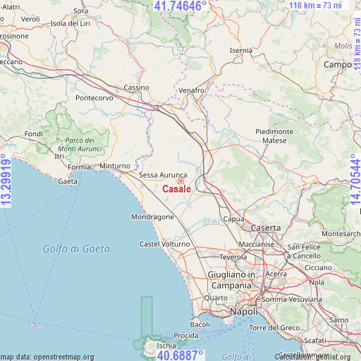
Casale GPS coordinates[2]
41° 13' 10.992" North, 14° 0' 8.316" East
| Map corner | latitude | longitude |
|---|---|---|
| Upper-left | 41.74646°, | 13.29919° |
| Center: | 41.21972°, | 14.00231° |
| Lower-right: | 40.6887°, | 14.70544° |
| Map W x H: | 117.6×117.6 km | = 73.1×73.1mi |
| max Lat: | 47.04031° ⇑76.7% North |
| Casale: | 41.21972° |
| min Lat: | ⇓23.3% South 35.50142° |
| min Long | Casale | max Long |
| 6.69888° | 14.00231° | 18.48682° |
| W 78.2%⇐ | ⇒21.8% E |
Elevation
Elevation of Casale is 178 m = 584 ft, and this is 128.7 m = 422 ft below average elevation for this country.
| Max E: |
2085 m = 6841 ft | 58.2% |
| Avg. | 306.7 m = 1006 ft | |
| Casale | 178 m = 584 ft | |
Min E: |
-4 m = -13 ft | 41.8% |
See also: Italy elevation on elevation.city.
Geographical zone
Casale is located in North temperate zone (between Tropic of Cancer and the Arctic Circle). Distance of this Northern Tropic circle is 1977.3 km =1228.6 mi to South.| Distance of | km | miles | from Casale |
|---|---|---|---|
| North Pole | 5423.9 | 3370.3 | to North |
| Arctic Circle | 2818 | 1751 | to North |
| Tropic Cancer | 1977.3 | 1228.6 | to South |
| Equator | 4583.2 | 2847.9 | to South |


Nearby cities:
15 places around Casale: (largest is in red/bold)
• Avezzano-Sorbello
5.8 km =3.6 mi,  266°
266°
• Carano
7.9 km =4.9 mi,  258°
258°
• Carinola
3.9 km =2.4 mi,  205°
205°
• Casanova
4.4 km =2.7 mi,  227°
227°
• Cascano
3.1 km =1.9 mi,  296°
296°
• Casi
5.3 km =3.3 mi,  34°
34°
• Falciano del Massico
7.8 km =4.8 mi,  215°
215°
• Francolise
6 km =3.7 mi,  130°
130°
• Nocelleto
5.6 km =3.5 mi,  168°
168°
• Roccamonfina
7.7 km =4.8 mi,  345°
345°
• San Marco
1.6 km =1 mi,  75°
75°
• Sant'Agata
5.5 km =3.4 mi,  278°
278°
• Scalo Ferroviario
6.2 km =3.9 mi, 76°
• Sessa Aurunca
6.5 km =4 mi,  290°
290°
• Teano
6.4 km =4 mi,  56°
56°
Sources, notices
• [Note1] Compared only with cities in Italy existing in our database
• [Src1] Map data: © OpenStreetMap contributors (CC-BY-SA)
• [Src2] Other city data from geonames.org with taken over terms of usage.
• [Src3] Geographical zone / Annual Mean Temperature by Robert A. Rohde @ Wikipedia
