Laveno geodata
Laveno (Lombardy) is a seat of a third-order administrative division; located in Italy in Europe/Rome (GMT+2) time zone. With population of 8,130 people, there are 1192 cities with bigger population in this country. Compared to other cities in Italy, 89.5% of cities are located further ↓South; 86.5% of cities are located further →East and 55.2% of cities have higher elevation than Laveno. Note1


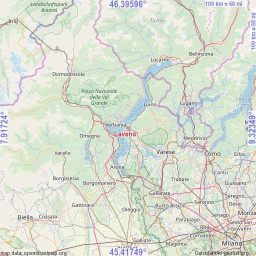
Laveno GPS coordinates[2]
45° 54' 31.968" North, 8° 37' 13.296" East
| Map corner | latitude | longitude |
|---|---|---|
| Upper-left | 46.39596°, | 7.91724° |
| Center: | 45.90888°, | 8.62036° |
| Lower-right: | 45.41749°, | 9.32349° |
| Map W x H: | 108.8×108.8 km | = 67.6×67.6mi |
| max Lat: | 47.04031° ⇑10.5% North |
| Laveno: | 45.90888° |
| min Lat: | ⇓89.5% South 35.50142° |
| min Long | Laveno | max Long |
| 6.69888° | 8.62036° | 18.48682° |
| W 13.5%⇐ | ⇒86.5% E |
Elevation
Elevation of Laveno is 201 m = 659 ft, and this is 105.7 m = 347 ft below average elevation for this country.
| Max E: |
2085 m = 6841 ft | 55.2% |
| Avg. | 306.7 m = 1006 ft | |
| Laveno | 201 m = 659 ft | |
Min E: |
-4 m = -13 ft | 44.8% |
See also: Italy elevation on elevation.city.
Geographical zone
Laveno is located in North temperate zone (between Tropic of Cancer and the Arctic Circle). Distance of this North polar circle is 2296.6 km =1427 mi to North.| Distance of | km | miles | from Laveno |
|---|---|---|---|
| North Pole | 4902.5 | 3046.3 | to North |
| Arctic Circle | 2296.6 | 1427 | to North |
| Tropic Cancer | 2498.7 | 1552.6 | to South |
| Equator | 5104.6 | 3171.9 | to South |


Nearby cities:
15 places around Laveno: (largest is in red/bold)
• Arizzano
6.1 km =3.8 mi,  331°
331°
• Brenta
5.2 km =3.2 mi,  108°
108°
• Caldana
7 km =4.3 mi,  126°
126°
• Caravate
4.3 km =2.7 mi,  142°
142°
• Casalzuigno
6.9 km =4.3 mi,  93°
93°
• Castello
6.2 km =3.9 mi,  43°
43°
• Castelveccana
5.6 km =3.5 mi, 39°
• Cittiglio
3.8 km =2.4 mi, 112°
• Gemonio
5.4 km =3.4 mi, 128°
• Ghiffa
5.1 km =3.2 mi,  345°
345°
• Leggiuno
3.7 km =2.3 mi,  179°
179°
• Monvalle
5.7 km =3.5 mi,  171°
171°
• Pallanza-Intra-Suna
5 km =3.1 mi,  310°
310°
• Sangiano
3.9 km =2.4 mi, 165°
• Verbania
5.5 km =3.4 mi,  284°
284°
In other languages:
- In France: Laveno-Mombello
- In German: Laveno-Mombello
- In Italian: Laveno-Mombello
- In Russian: Лавено-Момбелло
Sources, notices
• [Note1] Compared only with cities in Italy existing in our database
• [Src1] Map data: © OpenStreetMap contributors (CC-BY-SA)
• [Src2] Other city data from geonames.org with taken over terms of usage.
• [Src3] Geographical zone / Annual Mean Temperature by Robert A. Rohde @ Wikipedia
