Arzercavalli geodata
Arzercavalli (Veneto) is a populated place; located in Italy in Europe/Rome (GMT+2) time zone. With population of 557 people, there are 9383 cities with bigger population in this country. Compared to other cities in Italy, 66% of cities are located further ↓South; 55.1% of cities are located further ←West and 99.7% of cities have higher elevation than Arzercavalli. Note1


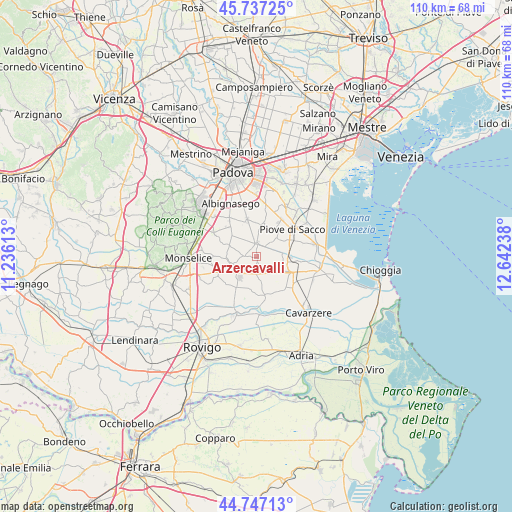
Arzercavalli GPS coordinates[2]
45° 14' 39.66" North, 11° 56' 21.3" East
| Map corner | latitude | longitude |
|---|---|---|
| Upper-left | 45.73725°, | 11.23613° |
| Center: | 45.24435°, | 11.93925° |
| Lower-right: | 44.74713°, | 12.64238° |
| Map W x H: | 110.1×110.1 km | = 68.4×68.4mi |
| max Lat: | 47.04031° ⇑34% North |
| Arzercavalli: | 45.24435° |
| min Lat: | ⇓66% South 35.50142° |
| min Long | Arzercavalli | max Long |
| 6.69888° | 11.93925° | 18.48682° |
| W 55.1%⇐ | ⇒44.9% E |
Elevation
Elevation of Arzercavalli is 0 m = 0 ft, and this is 306.7 m = 1006 ft below average elevation for this country.
| Max E: |
2085 m = 6841 ft | 99.7% |
| Avg. | 306.7 m = 1006 ft | |
| Arzercavalli | 0 m = 0 ft | |
Min E: |
-4 m = -13 ft | 0.3% |
See also: Italy elevation on elevation.city.
Geographical zone
Arzercavalli is located in North temperate zone (between Tropic of Cancer and the Arctic Circle). Distance of this North polar circle is 2370.5 km =1473 mi to North.| Distance of | km | miles | from Arzercavalli |
|---|---|---|---|
| North Pole | 4976.4 | 3092.2 | to North |
| Arctic Circle | 2370.5 | 1473 | to North |
| Tropic Cancer | 2424.8 | 1506.7 | to South |
| Equator | 5030.7 | 3125.9 | to South |


Nearby cities:
15 places around Arzercavalli: (largest is in red/bold)
• Arre
3.1 km =1.9 mi,  195°
195°
• Arzerello
7.5 km =4.7 mi,  64°
64°
• Bagnoli di Sopra
7.7 km =4.8 mi,  213°
213°
• Bovolenta
2.7 km =1.7 mi,  354°
354°
• Brugine
7.2 km =4.5 mi,  35°
35°
• Cagnola
7 km =4.3 mi,  307°
307°
• Campagnola
6 km =3.7 mi,  50°
50°
• Candiana
4.9 km =3 mi,  120°
120°
• Cartura
7 km =4.3 mi,  292°
292°
• Casalserugo
8.2 km =5.1 mi, 345°
• Conselve
5.2 km =3.2 mi,  254°
254°
• Polverara
7.3 km =4.5 mi,  9°
9°
• Pontelongo
6.8 km =4.2 mi,  88°
88°
• Terrassa Padovana
2.9 km =1.8 mi,  269°
269°
• Villa del Bosco
7.8 km =4.8 mi,  113°
113°
Sources, notices
• [Note1] Compared only with cities in Italy existing in our database
• [Src1] Map data: © OpenStreetMap contributors (CC-BY-SA)
• [Src2] Other city data from geonames.org with taken over terms of usage.
• [Src3] Geographical zone / Annual Mean Temperature by Robert A. Rohde @ Wikipedia
