Campagna geodata
Campagna (Campania) is a seat of a third-order administrative division; located in Italy in Europe/Rome (GMT+2) time zone. With population of 2,782 people, there are 3236 cities with bigger population in this country. Compared to other cities in Italy, 82.8% of cities are located further ↑North; 88% of cities are located further ←West and 58.2% of cities have lower elevation than Campagna. Note1


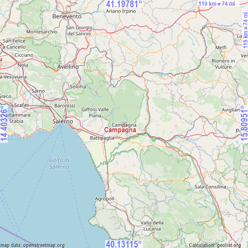
Campagna GPS coordinates[2]
40° 39' 59.796" North, 15° 6' 22.968" East
| Map corner | latitude | longitude |
|---|---|---|
| Upper-left | 41.19781°, | 14.40326° |
| Center: | 40.66661°, | 15.10638° |
| Lower-right: | 40.13115°, | 15.80951° |
| Map W x H: | 118.6×118.6 km | = 73.7×73.7mi |
| max Lat: | 47.04031° ⇑82.8% North |
| Campagna: | 40.66661° |
| min Lat: | ⇓17.2% South 35.50142° |
| min Long | Campagna | max Long |
| 6.69888° | 15.10638° | 18.48682° |
| W 88%⇐ | ⇒12% E |
Elevation
Elevation of Campagna is 287 m = 942 ft, and this is 19.7 m = 65 ft below average elevation for this country.
| Max E: |
2085 m = 6841 ft | 41.8% |
| Avg. | 306.7 m = 1006 ft | |
| Campagna | 287 m = 942 ft | |
Min E: |
-4 m = -13 ft | 58.2% |
See also: Italy elevation on elevation.city.
Geographical zone
Campagna is located in North temperate zone (between Tropic of Cancer and the Arctic Circle). Distance of this Northern Tropic circle is 1915.8 km =1190.4 mi to South.| Distance of | km | miles | from Campagna |
|---|---|---|---|
| North Pole | 5485.4 | 3408.5 | to North |
| Arctic Circle | 2879.5 | 1789.2 | to North |
| Tropic Cancer | 1915.8 | 1190.4 | to South |
| Equator | 4521.7 | 2809.7 | to South |


Nearby cities:
15 places around Campagna: (largest is in red/bold)
• Acerno
8.9 km =5.5 mi,  332°
332°
• Ariano
7 km =4.3 mi,  260°
260°
• Contursi Terme
11.6 km =7.2 mi,  99°
99°
• Eboli
6.9 km =4.3 mi,  217°
217°
• Macchia
10.9 km =6.8 mi, 262°
• Montecorvino Rovella
11.1 km =6.9 mi,  284°
284°
• Monticelli
7.8 km =4.8 mi, 256°
• Olevano sul Tusciano
7.1 km =4.4 mi, 261°
• Oliveto Citra
11 km =6.8 mi,  76°
76°
• Puglietta
4.3 km =2.7 mi,  114°
114°
• Quadrivio
4.6 km =2.9 mi,  182°
182°
• Salitto-Valle
7.1 km =4.4 mi, 276°
• Santa Lucia-Santa Maria la Nova
4.6 km =2.9 mi,  208°
208°
• Senerchia
11.8 km =7.3 mi,  45°
45°
• Serre
11.5 km =7.1 mi,  144°
144°
Sources, notices
• [Note1] Compared only with cities in Italy existing in our database
• [Src1] Map data: © OpenStreetMap contributors (CC-BY-SA)
• [Src2] Other city data from geonames.org with taken over terms of usage.
• [Src3] Geographical zone / Annual Mean Temperature by Robert A. Rohde @ Wikipedia
