Caianello geodata
Caianello (Campania) is a populated place; located in Italy in Europe/Rome (GMT+2) time zone. With population of 1,758 people, there are 4556 cities with bigger population in this country. Compared to other cities in Italy, 76.1% of cities are located further ↑North; 78.8% of cities are located further ←West and 55.1% of cities have higher elevation than Caianello. Note1


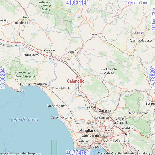
Caianello GPS coordinates[2]
41° 18' 18.324" North, 14° 5' 6.576" East
| Map corner | latitude | longitude |
|---|---|---|
| Upper-left | 41.83114°, | 13.38204° |
| Center: | 41.30509°, | 14.08516° |
| Lower-right: | 40.77476°, | 14.78829° |
| Map W x H: | 117.5×117.5 km | = 73×73mi |
| max Lat: | 47.04031° ⇑76.1% North |
| Caianello: | 41.30509° |
| min Lat: | ⇓23.9% South 35.50142° |
| min Long | Caianello | max Long |
| 6.69888° | 14.08516° | 18.48682° |
| W 78.8%⇐ | ⇒21.2% E |
Elevation
Elevation of Caianello is 202 m = 663 ft, and this is 104.7 m = 344 ft below average elevation for this country.
| Max E: |
2085 m = 6841 ft | 55.1% |
| Avg. | 306.7 m = 1006 ft | |
| Caianello | 202 m = 663 ft | |
Min E: |
-4 m = -13 ft | 44.9% |
See also: Italy elevation on elevation.city.
Geographical zone
Caianello is located in North temperate zone (between Tropic of Cancer and the Arctic Circle). Distance of this Northern Tropic circle is 1986.8 km =1234.5 mi to South.| Distance of | km | miles | from Caianello |
|---|---|---|---|
| North Pole | 5414.4 | 3364.4 | to North |
| Arctic Circle | 2808.5 | 1745.1 | to North |
| Tropic Cancer | 1986.8 | 1234.5 | to South |
| Equator | 4592.7 | 2853.8 | to South |


Nearby cities:
15 places around Caianello: (largest is in red/bold)
• Casi
6.5 km =4 mi,  217°
217°
• Conca della Campania
8.4 km =5.2 mi,  290°
290°
• Grottola
3.9 km =2.4 mi, 289°
• Marzanello
2.8 km =1.7 mi,  68°
68°
• Marzano Appio
3.6 km =2.2 mi, 292°
• Montano
1.4 km =0.9 mi,  83°
83°
• Pietravairano
7.1 km =4.4 mi, 71°
• Presenzano
8.2 km =5.1 mi,  3°
3°
• Riardo
7.3 km =4.5 mi,  131°
131°
• Roccamonfina
9.1 km =5.7 mi,  257°
257°
• Santa Lucia
0.5 km =0.3 mi, 257°
• Scalo Ferroviario
8.1 km =5 mi,  186°
186°
• Teano
6.2 km =3.9 mi, 194°
• Tora
6.4 km =4 mi,  307°
307°
• Vairano-Patenora
5.2 km =3.2 mi,  47°
47°
Sources, notices
• [Note1] Compared only with cities in Italy existing in our database
• [Src1] Map data: © OpenStreetMap contributors (CC-BY-SA)
• [Src2] Other city data from geonames.org with taken over terms of usage.
• [Src3] Geographical zone / Annual Mean Temperature by Robert A. Rohde @ Wikipedia
