Marzanello geodata
Marzanello (Campania) is a populated place; located in Italy in Europe/Rome (GMT+2) time zone. With population of 3,012 people, there are 3030 cities with bigger population in this country. Compared to other cities in Italy, 76% of cities are located further ↑North; 79.1% of cities are located further ←West and 62% of cities have higher elevation than Marzanello. Note1
Administrative division(s):
- Level 1: Campania
- Level 2: Provincia di Caserta
- Level 3: Vairano Patenora


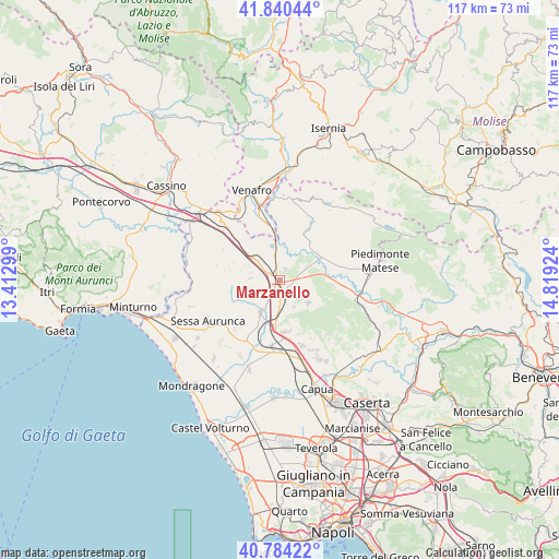
Marzanello GPS coordinates[2]
41° 18' 52.092" North, 14° 6' 57.996" East
| Map corner | latitude | longitude |
|---|---|---|
| Upper-left | 41.84044°, | 13.41299° |
| Center: | 41.31447°, | 14.11611° |
| Lower-right: | 40.78422°, | 14.81924° |
| Map W x H: | 117.4×117.4 km | = 72.9×72.9mi |
| max Lat: | 47.04031° ⇑76% North |
| Marzanello: | 41.31447° |
| min Lat: | ⇓24% South 35.50142° |
| min Long | Marzanello | max Long |
| 6.69888° | 14.11611° | 18.48682° |
| W 79.1%⇐ | ⇒20.9% E |
Elevation
Elevation of Marzanello is 149 m = 489 ft, and this is 157.7 m = 517 ft below average elevation for this country.
| Max E: |
2085 m = 6841 ft | 62% |
| Avg. | 306.7 m = 1006 ft | |
| Marzanello | 149 m = 489 ft | |
Min E: |
-4 m = -13 ft | 38% |
See also: Italy elevation on elevation.city.
Geographical zone
Marzanello is located in North temperate zone (between Tropic of Cancer and the Arctic Circle). Distance of this Northern Tropic circle is 1987.8 km =1235.2 mi to South.| Distance of | km | miles | from Marzanello |
|---|---|---|---|
| North Pole | 5413.3 | 3363.7 | to North |
| Arctic Circle | 2807.4 | 1744.4 | to North |
| Tropic Cancer | 1987.8 | 1235.2 | to South |
| Equator | 4593.7 | 2854.4 | to South |


Nearby cities:
15 places around Marzanello: (largest is in red/bold)
• Caianello
2.8 km =1.7 mi,  248°
248°
• Casi
9 km =5.6 mi,  226°
226°
• Grottola
6.3 km =3.9 mi,  272°
272°
• Marzano Appio
5.9 km =3.7 mi, 273°
• Montano
1.5 km =0.9 mi, 233°
• Pietramelara
7.7 km =4.8 mi,  129°
129°
• Pietravairano
4.3 km =2.7 mi,  73°
73°
• Presenzano
7.4 km =4.6 mi,  343°
343°
• Riardo
6.5 km =4 mi,  153°
153°
• Rocchetta
9.3 km =5.8 mi,  158°
158°
• Santa Lucia
3.3 km =2.1 mi, 249°
• Scalo Ferroviario
9.7 km =6 mi,  200°
200°
• Teano
8.2 km =5.1 mi,  210°
210°
• Tora
8.2 km =5.1 mi,  290°
290°
• Vairano-Patenora
2.8 km =1.7 mi,  26°
26°
Sources, notices
• [Note1] Compared only with cities in Italy existing in our database
• [Src1] Map data: © OpenStreetMap contributors (CC-BY-SA)
• [Src2] Other city data from geonames.org with taken over terms of usage.
• [Src3] Geographical zone / Annual Mean Temperature by Robert A. Rohde @ Wikipedia
