Padova geodata
Padova (Veneto) is a seat of a second-order administrative division; located in Italy in Europe/Rome (GMT+2) time zone. With population of 203,725 people, there are 12 cities with bigger population in this country. Compared to other cities in Italy, 70.5% of cities are located further ↓South; 54.4% of cities are located further ←West and 90.1% of cities have higher elevation than Padova. Note1


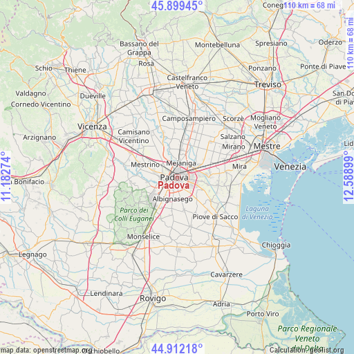
Padova GPS coordinates[2]
45° 24' 28.692" North, 11° 53' 9.096" East
| Map corner | latitude | longitude |
|---|---|---|
| Upper-left | 45.89945°, | 11.18274° |
| Center: | 45.40797°, | 11.88586° |
| Lower-right: | 44.91218°, | 12.58899° |
| Map W x H: | 109.8×109.8 km | = 68.2×68.2mi |
| max Lat: | 47.04031° ⇑29.5% North |
| Padova: | 45.40797° |
| min Lat: | ⇓70.5% South 35.50142° |
| min Long | Padova | max Long |
| 6.69888° | 11.88586° | 18.48682° |
| W 54.4%⇐ | ⇒45.6% E |
Elevation
Elevation of Padova is 18 m = 59 ft, and this is 288.7 m = 947 ft below average elevation for this country.
| Max E: |
2085 m = 6841 ft | 90.1% |
| Avg. | 306.7 m = 1006 ft | |
| Padova | 18 m = 59 ft | |
Min E: |
-4 m = -13 ft | 9.9% |
See also: Padova elevation on elevation.city.
Geographical zone
Padova is located in North temperate zone (between Tropic of Cancer and the Arctic Circle). Distance of this North polar circle is 2352.3 km =1461.7 mi to North.| Distance of | km | miles | from Padova |
|---|---|---|---|
| North Pole | 4958.2 | 3080.9 | to North |
| Arctic Circle | 2352.3 | 1461.7 | to North |
| Tropic Cancer | 2443 | 1518 | to South |
| Equator | 5048.9 | 3137.2 | to South |


Nearby cities:
15 places around Padova: (largest is in red/bold)
• Albignasego
6.9 km =4.3 mi,  191°
191°
• Cadoneghe
5.1 km =3.2 mi,  39°
39°
• Caselle
5.4 km =3.4 mi,  273°
273°
• Mandriola-Sant'Agostino
5.1 km =3.2 mi,  212°
212°
• Mejaniga
5.8 km =3.6 mi,  16°
16°
• Noventa
5.1 km =3.2 mi,  82°
82°
• Ponte San Nicolò
5.4 km =3.4 mi,  147°
147°
• Ponterotto-Giustizia
6.7 km =4.2 mi,  317°
317°
• San Vito
6.1 km =3.8 mi, 78°
• Sarmeola
5.7 km =3.5 mi,  288°
288°
• Tencarola
6.2 km =3.9 mi,  256°
256°
• Vigodarzere
5.5 km =3.4 mi,  359°
359°
• Vigonza
7.5 km =4.7 mi,  66°
66°
• Villaguattera
6.7 km =4.2 mi,  307°
307°
• Villatora
6.8 km =4.2 mi,  109°
109°
In other languages:
- In Spanish: Padua
- In France: Padoue
- In German: Padua
- In Russian: Падуя
- In Chinese: 帕多瓦
Sources, notices
• [Note1] Compared only with cities in Italy existing in our database
• [Src1] Map data: © OpenStreetMap contributors (CC-BY-SA)
• [Src2] Other city data from geonames.org with taken over terms of usage.
• [Src3] Geographical zone / Annual Mean Temperature by Robert A. Rohde @ Wikipedia
