Vigodarzere geodata
Vigodarzere (Veneto) is a seat of a third-order administrative division; located in Italy in Europe/Rome (GMT+2) time zone. With population of 6,278 people, there are 1557 cities with bigger population in this country. Compared to other cities in Italy, 72.1% of cities are located further ↓South; 54.3% of cities are located further ←West and 92.1% of cities have higher elevation than Vigodarzere. Note1


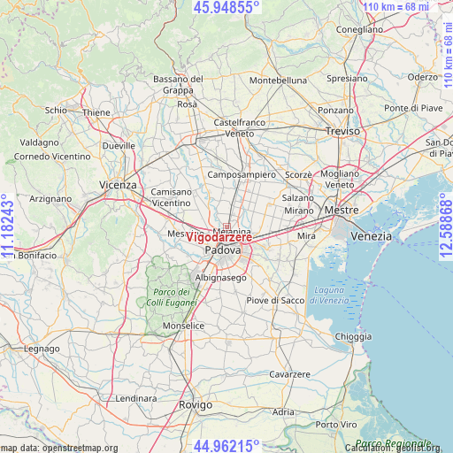
Vigodarzere GPS coordinates[2]
45° 27' 27.036" North, 11° 53' 7.98" East
| Map corner | latitude | longitude |
|---|---|---|
| Upper-left | 45.94855°, | 11.18243° |
| Center: | 45.45751°, | 11.88555° |
| Lower-right: | 44.96215°, | 12.58868° |
| Map W x H: | 109.7×109.7 km | = 68.2×68.2mi |
| max Lat: | 47.04031° ⇑27.9% North |
| Vigodarzere: | 45.45751° |
| min Lat: | ⇓72.1% South 35.50142° |
| min Long | Vigodarzere | max Long |
| 6.69888° | 11.88555° | 18.48682° |
| W 54.3%⇐ | ⇒45.7% E |
Elevation
Elevation of Vigodarzere is 14 m = 46 ft, and this is 292.7 m = 960 ft below average elevation for this country.
| Max E: |
2085 m = 6841 ft | 92.1% |
| Avg. | 306.7 m = 1006 ft | |
| Vigodarzere | 14 m = 46 ft | |
Min E: |
-4 m = -13 ft | 7.9% |
See also: Italy elevation on elevation.city.
Geographical zone
Vigodarzere is located in North temperate zone (between Tropic of Cancer and the Arctic Circle). Distance of this North polar circle is 2346.8 km =1458.2 mi to North.| Distance of | km | miles | from Vigodarzere |
|---|---|---|---|
| North Pole | 4952.7 | 3077.5 | to North |
| Arctic Circle | 2346.8 | 1458.2 | to North |
| Tropic Cancer | 2448.5 | 1521.4 | to South |
| Equator | 5054.4 | 3140.7 | to South |


Nearby cities:
15 places around Vigodarzere: (largest is in red/bold)
• Cadoneghe
3.7 km =2.3 mi,  116°
116°
• Campodarsego
5.3 km =3.3 mi,  32°
32°
• Codiverno
5.1 km =3.2 mi,  66°
66°
• Limena
3.4 km =2.1 mi,  293°
293°
• Mejaniga
1.6 km =1 mi,  89°
89°
• Padova
5.5 km =3.4 mi,  179°
179°
• Pionca
6.1 km =3.8 mi,  81°
81°
• Ponterotto-Giustizia
4.5 km =2.8 mi,  263°
263°
• Prisco-Sandrin Piccolo
3.9 km =2.4 mi,  327°
327°
• Saletto
2.7 km =1.7 mi,  313°
313°
• Sarmeola
6.5 km =4 mi,  235°
235°
• Taggì
5.2 km =3.2 mi,  273°
273°
• Tavo
5.2 km =3.2 mi,  338°
338°
• Terraglione
3.1 km =1.9 mi,  16°
16°
• Villaguattera
5.5 km =3.4 mi,  254°
254°
Sources, notices
• [Note1] Compared only with cities in Italy existing in our database
• [Src1] Map data: © OpenStreetMap contributors (CC-BY-SA)
• [Src2] Other city data from geonames.org with taken over terms of usage.
• [Src3] Geographical zone / Annual Mean Temperature by Robert A. Rohde @ Wikipedia
