Santa Lucia geodata
Santa Lucia (Veneto) is a populated place; located in Italy in Europe/Rome (GMT+2) time zone. With population of 533 people, there are 9616 cities with bigger population in this country. Compared to other cities in Italy, 73.7% of cities are located further ↓South; 59.5% of cities are located further →East and 68.5% of cities have higher elevation than Santa Lucia. Note1


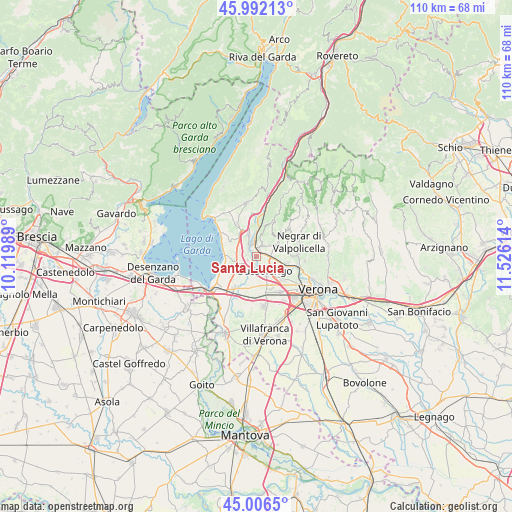
Santa Lucia GPS coordinates[2]
45° 30' 5.292" North, 10° 49' 22.836" East
| Map corner | latitude | longitude |
|---|---|---|
| Upper-left | 45.99213°, | 10.11989° |
| Center: | 45.50147°, | 10.82301° |
| Lower-right: | 45.0065°, | 11.52614° |
| Map W x H: | 109.6×109.6 km | = 68.1×68.1mi |
| max Lat: | 47.04031° ⇑26.3% North |
| Santa Lucia: | 45.50147° |
| min Lat: | ⇓73.7% South 35.50142° |
| min Long | Santa Lucia | max Long |
| 6.69888° | 10.82301° | 18.48682° |
| W 40.5%⇐ | ⇒59.5% E |
Elevation
Elevation of Santa Lucia is 106 m = 348 ft, and this is 200.7 m = 658 ft below average elevation for this country.
| Max E: |
2085 m = 6841 ft | 68.5% |
| Avg. | 306.7 m = 1006 ft | |
| Santa Lucia | 106 m = 348 ft | |
Min E: |
-4 m = -13 ft | 31.5% |
See also: Italy elevation on elevation.city.
Geographical zone
Santa Lucia is located in North temperate zone (between Tropic of Cancer and the Arctic Circle). Distance of this North polar circle is 2341.9 km =1455.2 mi to North.| Distance of | km | miles | from Santa Lucia |
|---|---|---|---|
| North Pole | 4947.8 | 3074.4 | to North |
| Arctic Circle | 2341.9 | 1455.2 | to North |
| Tropic Cancer | 2453.4 | 1524.5 | to South |
| Equator | 5059.3 | 3143.7 | to South |


Nearby cities:
15 places around Santa Lucia: (largest is in red/bold)
• Affi
6.4 km =4 mi,  333°
333°
• Bure
4.7 km =2.9 mi,  53°
53°
• Bussolengo
4.3 km =2.7 mi,  146°
146°
• Calmasino
5.9 km =3.7 mi,  291°
291°
• Cavajon Veronese
5.9 km =3.7 mi,  316°
316°
• Ospedaletto
1.5 km =0.9 mi,  76°
76°
• Pastrengo
2 km =1.2 mi,  251°
251°
• Pescantina
3.9 km =2.4 mi,  116°
116°
• San Pietro in Cariano
5.2 km =3.2 mi,  70°
70°
• San Vito al Mantico
6.3 km =3.9 mi, 121°
• Sandrà
5.3 km =3.3 mi,  211°
211°
• Sant'Ambrogio di Valpollicella
2.4 km =1.5 mi,  25°
25°
• Sega
2.6 km =1.6 mi, 321°
• Via Pastrengo
2.9 km =1.8 mi,  170°
170°
• Volargne
4 km =2.5 mi,  354°
354°
Sources, notices
• [Note1] Compared only with cities in Italy existing in our database
• [Src1] Map data: © OpenStreetMap contributors (CC-BY-SA)
• [Src2] Other city data from geonames.org with taken over terms of usage.
• [Src3] Geographical zone / Annual Mean Temperature by Robert A. Rohde @ Wikipedia
