Sandrà geodata
Sandrà (Veneto) is a populated place; located in Italy in Europe/Rome (GMT+2) time zone. With population of 2,219 people, there are 3847 cities with bigger population in this country. Compared to other cities in Italy, 72.2% of cities are located further ↓South; 59.8% of cities are located further →East and 61.3% of cities have higher elevation than Sandrà. Note1
Administrative division(s):
- Level 1: Veneto
- Level 2: Provincia di Verona
- Level 3: Castelnuovo del Garda


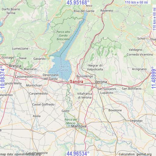
Sandrà GPS coordinates[2]
45° 27' 38.412" North, 10° 47' 12.696" East
| Map corner | latitude | longitude |
|---|---|---|
| Upper-left | 45.95168°, | 10.08374° |
| Center: | 45.46067°, | 10.78686° |
| Lower-right: | 44.96534°, | 11.48999° |
| Map W x H: | 109.7×109.7 km | = 68.2×68.2mi |
| max Lat: | 47.04031° ⇑27.8% North |
| Sandrà: | 45.46067° |
| min Lat: | ⇓72.2% South 35.50142° |
| min Long | Sandrà | max Long |
| 6.69888° | 10.78686° | 18.48682° |
| W 40.2%⇐ | ⇒59.8% E |
Elevation
Elevation of Sandrà is 153 m = 502 ft, and this is 153.7 m = 504 ft below average elevation for this country.
| Max E: |
2085 m = 6841 ft | 61.3% |
| Avg. | 306.7 m = 1006 ft | |
| Sandrà | 153 m = 502 ft | |
Min E: |
-4 m = -13 ft | 38.7% |
See also: Italy elevation on elevation.city.
Geographical zone
Sandrà is located in North temperate zone (between Tropic of Cancer and the Arctic Circle). Distance of this North polar circle is 2346.4 km =1458 mi to North.| Distance of | km | miles | from Sandrà |
|---|---|---|---|
| North Pole | 4952.3 | 3077.2 | to North |
| Arctic Circle | 2346.4 | 1458 | to North |
| Tropic Cancer | 2448.8 | 1521.6 | to South |
| Equator | 5054.8 | 3140.9 | to South |


Nearby cities:
15 places around Sandrà: (largest is in red/bold)
• Bussolengo
5.3 km =3.3 mi,  79°
79°
• Calmasino
7.2 km =4.5 mi,  337°
337°
• Castelnuovo del Garda
3.2 km =2 mi,  220°
220°
• Cavalcaselle
5.4 km =3.4 mi,  240°
240°
• Colà
3.8 km =2.4 mi,  293°
293°
• Lazise
6.2 km =3.9 mi,  323°
323°
• Ospedaletto
6.5 km =4 mi,  41°
41°
• Pastrengo
4 km =2.5 mi,  13°
13°
• Pescantina
6.9 km =4.3 mi,  66°
66°
• San Giorgio in Salici
3.8 km =2.4 mi,  177°
177°
• Santa Lucia
5.3 km =3.3 mi,  31°
31°
• Sega
6.7 km =4.2 mi, 10°
• Sommacampagna
7.6 km =4.7 mi,  144°
144°
• Sona
5.2 km =3.2 mi,  126°
126°
• Via Pastrengo
3.7 km =2.3 mi,  62°
62°
Sources, notices
• [Note1] Compared only with cities in Italy existing in our database
• [Src1] Map data: © OpenStreetMap contributors (CC-BY-SA)
• [Src2] Other city data from geonames.org with taken over terms of usage.
• [Src3] Geographical zone / Annual Mean Temperature by Robert A. Rohde @ Wikipedia
