Roncajette geodata
Roncajette (Veneto) is a populated place; located in Italy in Europe/Rome (GMT+2) time zone. With population of 750 people, there are 7955 cities with bigger population in this country. Compared to other cities in Italy, 68.7% of cities are located further ↓South; 55% of cities are located further ←West and 95.9% of cities have higher elevation than Roncajette. Note1


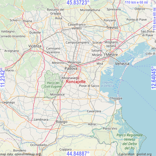
Roncajette GPS coordinates[2]
45° 20' 42.756" North, 11° 56' 14.352" East
| Map corner | latitude | longitude |
|---|---|---|
| Upper-left | 45.83723°, | 11.2342° |
| Center: | 45.34521°, | 11.93732° |
| Lower-right: | 44.84887°, | 12.64045° |
| Map W x H: | 109.9×109.9 km | = 68.3×68.3mi |
| max Lat: | 47.04031° ⇑31.3% North |
| Roncajette: | 45.34521° |
| min Lat: | ⇓68.7% South 35.50142° |
| min Long | Roncajette | max Long |
| 6.69888° | 11.93732° | 18.48682° |
| W 55%⇐ | ⇒45% E |
Elevation
Elevation of Roncajette is 7 m = 23 ft, and this is 299.7 m = 983 ft below average elevation for this country.
| Max E: |
2085 m = 6841 ft | 95.9% |
| Avg. | 306.7 m = 1006 ft | |
| Roncajette | 7 m = 23 ft | |
Min E: |
-4 m = -13 ft | 4.1% |
See also: Italy elevation on elevation.city.
Geographical zone
Roncajette is located in North temperate zone (between Tropic of Cancer and the Arctic Circle). Distance of this North polar circle is 2359.3 km =1466 mi to North.| Distance of | km | miles | from Roncajette |
|---|---|---|---|
| North Pole | 4965.1 | 3085.2 | to North |
| Arctic Circle | 2359.3 | 1466 | to North |
| Tropic Cancer | 2436 | 1513.7 | to South |
| Equator | 5041.9 | 3132.9 | to South |


Nearby cities:
15 places around Roncajette: (largest is in red/bold)
• Albignasego
5.4 km =3.4 mi,  272°
272°
• Bertipaglia
5.2 km =3.2 mi,  231°
231°
• Brugine
6.9 km =4.3 mi,  141°
141°
• Campolongo Maggiore Liettoli
6.8 km =4.2 mi,  95°
95°
• Casalserugo
3.8 km =2.4 mi,  210°
210°
• Legnaro
2.2 km =1.4 mi, 98°
• Mandriola-Sant'Agostino
7.3 km =4.5 mi,  291°
291°
• Maserà di Padova
6.4 km =4 mi,  241°
241°
• Polverara
4.2 km =2.6 mi,  161°
161°
• Ponte San Nicolò
2.7 km =1.7 mi,  336°
336°
• Sant'Angelo di Piove di Sacco
6.4 km =4 mi,  118°
118°
• Saonara
4.3 km =2.7 mi,  58°
58°
• Tombelle
6.9 km =4.3 mi,  30°
30°
• Vigonovo
7.1 km =4.4 mi,  49°
49°
• Villatora
5.3 km =3.3 mi, 26°
Sources, notices
• [Note1] Compared only with cities in Italy existing in our database
• [Src1] Map data: © OpenStreetMap contributors (CC-BY-SA)
• [Src2] Other city data from geonames.org with taken over terms of usage.
• [Src3] Geographical zone / Annual Mean Temperature by Robert A. Rohde @ Wikipedia
