Rho geodata
Rho (Lombardy) is a seat of a third-order administrative division; located in Italy in Europe/Rome (GMT+2) time zone. With population of 47,086 people, there are 132 cities with bigger population in this country. Compared to other cities in Italy, 74.7% of cities are located further ↓South; 80.7% of cities are located further →East and 60.4% of cities have higher elevation than Rho. Note1


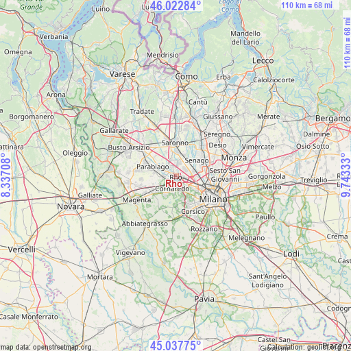
Rho GPS coordinates[2]
45° 31' 56.82" North, 9° 2' 24.72" East
| Map corner | latitude | longitude |
|---|---|---|
| Upper-left | 46.02284°, | 8.33708° |
| Center: | 45.53245°, | 9.0402° |
| Lower-right: | 45.03775°, | 9.74333° |
| Map W x H: | 109.5×109.5 km | = 68×68mi |
| max Lat: | 47.04031° ⇑25.3% North |
| Rho: | 45.53245° |
| min Lat: | ⇓74.7% South 35.50142° |
| min Long | Rho | max Long |
| 6.69888° | 9.0402° | 18.48682° |
| W 19.3%⇐ | ⇒80.7% E |
Elevation
Elevation of Rho is 160 m = 525 ft, and this is 146.7 m = 481 ft below average elevation for this country.
| Max E: |
2085 m = 6841 ft | 60.4% |
| Avg. | 306.7 m = 1006 ft | |
| Rho | 160 m = 525 ft | |
Min E: |
-4 m = -13 ft | 39.6% |
See also: Rho elevation on elevation.city.
Geographical zone
Rho is located in North temperate zone (between Tropic of Cancer and the Arctic Circle). Distance of this North polar circle is 2338.4 km =1453 mi to North.| Distance of | km | miles | from Rho |
|---|---|---|---|
| North Pole | 4944.3 | 3072.2 | to North |
| Arctic Circle | 2338.4 | 1453 | to North |
| Tropic Cancer | 2456.8 | 1526.6 | to South |
| Equator | 5062.7 | 3145.8 | to South |


Nearby cities:
15 places around Rho: (largest is in red/bold)
• Arese
3.5 km =2.2 mi,  55°
55°
• Baranzate
6 km =3.7 mi,  95°
95°
• Cornaredo
3.6 km =2.2 mi,  196°
196°
• Figino
5.3 km =3.3 mi,  146°
146°
• Garbagnate Milanese
5.4 km =3.4 mi,  30°
30°
• Lainate
4.5 km =2.8 mi,  346°
346°
• Mantegazza
5.8 km =3.6 mi,  243°
243°
• Nerviano
5.3 km =3.3 mi,  296°
296°
• Passirana
1.7 km =1.1 mi,  10°
10°
• Pero
4.4 km =2.7 mi,  124°
124°
• Pogliano Milanese
3.6 km =2.2 mi,  279°
279°
• Pregnana Milanese
3.2 km =2 mi,  234°
234°
• Settimo Milanese
6.2 km =3.9 mi,  168°
168°
• Vanzago
3.9 km =2.4 mi,  258°
258°
• Vighignolo
4.1 km =2.5 mi,  176°
176°
Sources, notices
• [Note1] Compared only with cities in Italy existing in our database
• [Src1] Map data: © OpenStreetMap contributors (CC-BY-SA)
• [Src2] Other city data from geonames.org with taken over terms of usage.
• [Src3] Geographical zone / Annual Mean Temperature by Robert A. Rohde @ Wikipedia
