Davagna geodata
Davagna (Liguria) is a seat of a third-order administrative division; located in Italy in Europe/Rome (GMT+2) time zone. With population of 218 people, there are 11044 cities with bigger population in this country. Compared to other cities in Italy, 50.5% of cities are located further ↓South; 79.9% of cities are located further →East and 80.6% of cities have lower elevation than Davagna. Note1


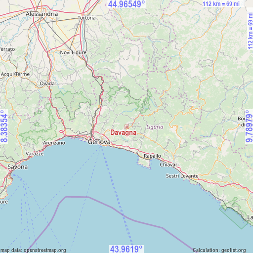
Davagna GPS coordinates[2]
44° 27' 57.06" North, 9° 5' 11.976" East
| Map corner | latitude | longitude |
|---|---|---|
| Upper-left | 44.96549°, | 8.38354° |
| Center: | 44.46585°, | 9.08666° |
| Lower-right: | 43.9619°, | 9.78979° |
| Map W x H: | 111.6×111.6 km | = 69.3×69.3mi |
| max Lat: | 47.04031° ⇑49.5% North |
| Davagna: | 44.46585° |
| min Lat: | ⇓50.5% South 35.50142° |
| min Long | Davagna | max Long |
| 6.69888° | 9.08666° | 18.48682° |
| W 20.1%⇐ | ⇒79.9% E |
Elevation
Elevation of Davagna is 533 m = 1749 ft, and this is 226.3 m = 742 ft above average elevation for this country.
| Max E: |
2085 m = 6841 ft | 19.4% |
| Davagna | 533 m 1749 ft | |
| Avg. | 306.7 m = 1006 ft | |
Min E: |
-4 m = -13 ft | 80.6% |
See also: Italy elevation on elevation.city.
Geographical zone
Davagna is located in North temperate zone (between Tropic of Cancer and the Arctic Circle). Distance of this Northern Tropic circle is 2338.2 km =1452.9 mi to South.| Distance of | km | miles | from Davagna |
|---|---|---|---|
| North Pole | 5062.9 | 3145.9 | to North |
| Arctic Circle | 2457 | 1526.7 | to North |
| Tropic Cancer | 2338.2 | 1452.9 | to South |
| Equator | 4944.1 | 3072.1 | to South |


Nearby cities:
15 places around Davagna: (largest is in red/bold)
• Bargagli
2.1 km =1.3 mi,  164°
164°
• Bogliasco
9.6 km =6 mi,  188°
188°
• Casella
10.3 km =6.4 mi,  318°
318°
• Ferriere
4.7 km =2.9 mi,  122°
122°
• Gattorna
8.7 km =5.4 mi, 116°
• Molino Vecchio-Scapitola-Baio
10.1 km =6.3 mi,  351°
351°
• Montoggio
6.4 km =4 mi,  332°
332°
• Neirone
8.4 km =5.2 mi,  98°
98°
• Piccarello
9.8 km =6.1 mi,  281°
281°
• Pieve Ligure
10.1 km =6.3 mi,  176°
176°
• Poggio Favaro-San Bernardo
9.3 km =5.8 mi, 183°
• Testana
9.1 km =5.7 mi,  148°
148°
• Torriglia
8.1 km =5 mi,  44°
44°
• Tribogna
10.2 km =6.3 mi, 122°
• Uscio
8.5 km =5.3 mi,  134°
134°
Sources, notices
• [Note1] Compared only with cities in Italy existing in our database
• [Src1] Map data: © OpenStreetMap contributors (CC-BY-SA)
• [Src2] Other city data from geonames.org with taken over terms of usage.
• [Src3] Geographical zone / Annual Mean Temperature by Robert A. Rohde @ Wikipedia
