Calizzano geodata
Calizzano (Liguria) is a seat of a third-order administrative division; located in Italy in Europe/Rome (GMT+2) time zone. With population of 1,138 people, there are 6157 cities with bigger population in this country. Compared to other cities in Italy, 52.4% of cities are located further ↑North; 92% of cities are located further →East and 87% of cities have lower elevation than Calizzano. Note1


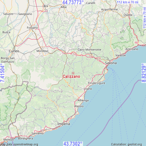
Calizzano GPS coordinates[2]
44° 14' 10.032" North, 8° 7' 5.412" East
| Map corner | latitude | longitude |
|---|---|---|
| Upper-left | 44.73773°, | 7.41504° |
| Center: | 44.23612°, | 8.11817° |
| Lower-right: | 43.7302°, | 8.82129° |
| Map W x H: | 112×112 km | = 69.6×69.6mi |
| max Lat: | 47.04031° ⇑52.4% North |
| Calizzano: | 44.23612° |
| min Lat: | ⇓47.6% South 35.50142° |
| min Long | Calizzano | max Long |
| 6.69888° | 8.11817° | 18.48682° |
| W 8%⇐ | ⇒92% E |
Elevation
Elevation of Calizzano is 651 m = 2136 ft, and this is 344.3 m = 1130 ft above average elevation for this country.
| Max E: |
2085 m = 6841 ft | 13% |
| Calizzano | 651 m 2136 ft | |
| Avg. | 306.7 m = 1006 ft | |
Min E: |
-4 m = -13 ft | 87% |
See also: Italy elevation on elevation.city.
Geographical zone
Calizzano is located in North temperate zone (between Tropic of Cancer and the Arctic Circle). Distance of this Northern Tropic circle is 2312.7 km =1437 mi to South.| Distance of | km | miles | from Calizzano |
|---|---|---|---|
| North Pole | 5088.5 | 3161.8 | to North |
| Arctic Circle | 2482.6 | 1542.6 | to North |
| Tropic Cancer | 2312.7 | 1437 | to South |
| Equator | 4918.6 | 3056.3 | to South |


Nearby cities:
15 places around Calizzano: (largest is in red/bold)
• Bagnasco
9.5 km =5.9 mi,  322°
322°
• Bardineto
5.3 km =3.3 mi,  165°
165°
• Bormida
10.2 km =6.3 mi,  62°
62°
• Castelvecchio di Rocca Barbena
11.8 km =7.3 mi,  180°
180°
• Erli
11.1 km =6.9 mi,  185°
185°
• Garessio
8.6 km =5.3 mi,  247°
247°
• Giustenice
12.2 km =7.6 mi,  125°
125°
• Magliolo
11.5 km =7.1 mi,  114°
114°
• Massimino
8 km =5 mi,  332°
332°
• Murialdo
9.8 km =6.1 mi,  23°
23°
• Osiglia
8.3 km =5.2 mi,  52°
52°
• Perlo
11 km =6.8 mi,  346°
346°
• Piano
9.8 km =6.1 mi, 23°
• Priola
7.8 km =4.8 mi,  277°
277°
• Rialto
11.5 km =7.1 mi,  95°
95°
Sources, notices
• [Note1] Compared only with cities in Italy existing in our database
• [Src1] Map data: © OpenStreetMap contributors (CC-BY-SA)
• [Src2] Other city data from geonames.org with taken over terms of usage.
• [Src3] Geographical zone / Annual Mean Temperature by Robert A. Rohde @ Wikipedia
