Bagnacavallo geodata
Bagnacavallo (Emilia-Romagna) is a seat of a third-order administrative division; located in Italy in Europe/Rome (GMT+2) time zone. With population of 8,550 people, there are 1114 cities with bigger population in this country. Compared to other cities in Italy, 50.2% of cities are located further ↑North; 55.6% of cities are located further ←West and 94.1% of cities have higher elevation than Bagnacavallo. Note1
Administrative division(s):
- Level 1: Emilia-Romagna
- Level 2: Provincia di Ravenna
- Level 3: Bagnacavallo


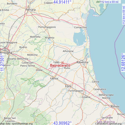
Bagnacavallo GPS coordinates[2]
44° 24' 50.472" North, 11° 58' 41.268" East
| Map corner | latitude | longitude |
|---|---|---|
| Upper-left | 44.91411°, | 11.27501° |
| Center: | 44.41402°, | 11.97813° |
| Lower-right: | 43.90962°, | 12.68126° |
| Map W x H: | 111.7×111.7 km | = 69.4×69.4mi |
| max Lat: | 47.04031° ⇑50.2% North |
| Bagnacavallo: | 44.41402° |
| min Lat: | ⇓49.8% South 35.50142° |
| min Long | Bagnacavallo | max Long |
| 6.69888° | 11.97813° | 18.48682° |
| W 55.6%⇐ | ⇒44.4% E |
Elevation
Elevation of Bagnacavallo is 10 m = 33 ft, and this is 296.7 m = 973 ft below average elevation for this country.
| Max E: |
2085 m = 6841 ft | 94.1% |
| Avg. | 306.7 m = 1006 ft | |
| Bagnacavallo | 10 m = 33 ft | |
Min E: |
-4 m = -13 ft | 5.9% |
See also: Italy elevation on elevation.city.
Geographical zone
Bagnacavallo is located in North temperate zone (between Tropic of Cancer and the Arctic Circle). Distance of this Northern Tropic circle is 2332.5 km =1449.3 mi to South.| Distance of | km | miles | from Bagnacavallo |
|---|---|---|---|
| North Pole | 5068.7 | 3149.5 | to North |
| Arctic Circle | 2462.8 | 1530.3 | to North |
| Tropic Cancer | 2332.5 | 1449.3 | to South |
| Equator | 4938.4 | 3068.6 | to South |


Nearby cities:
15 places around Bagnacavallo: (largest is in red/bold)
• Alfonsine
9.4 km =5.8 mi,  59°
59°
• Barbiano
7.8 km =4.8 mi,  249°
249°
• Cotignola
4.5 km =2.8 mi,  225°
225°
• Fusignano
6.1 km =3.8 mi,  343°
343°
• Godo
8.1 km =5 mi,  107°
107°
• Granarolo
7.1 km =4.4 mi,  209°
209°
• Lugo
5.4 km =3.4 mi,  278°
278°
• Masiera
5.4 km =3.4 mi,  349°
349°
• Piangipane
9 km =5.6 mi,  84°
84°
• Russi
6.1 km =3.8 mi,  133°
133°
• San Potito
3.7 km =2.3 mi,  303°
303°
• Sant'Agata sul Santerno
9.9 km =6.2 mi,  289°
289°
• Santerno
6.6 km =4.1 mi,  67°
67°
• Villa San Martino
8.8 km =5.5 mi,  271°
271°
• Villanova
6.8 km =4.2 mi, 56°
Sources, notices
• [Note1] Compared only with cities in Italy existing in our database
• [Src1] Map data: © OpenStreetMap contributors (CC-BY-SA)
• [Src2] Other city data from geonames.org with taken over terms of usage.
• [Src3] Geographical zone / Annual Mean Temperature by Robert A. Rohde @ Wikipedia
