Santerno geodata
Santerno (Emilia-Romagna) is a populated place; located in Italy in Europe/Rome (GMT+2) time zone. With population of 1,012 people, there are 6622 cities with bigger population in this country. Compared to other cities in Italy, 50.1% of cities are located further ↓South; 56.7% of cities are located further ←West and 96.6% of cities have higher elevation than Santerno. Note1


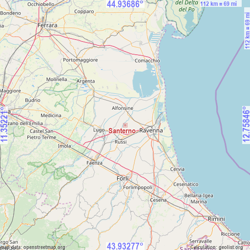
Santerno GPS coordinates[2]
44° 26' 13.092" North, 12° 3' 19.188" East
| Map corner | latitude | longitude |
|---|---|---|
| Upper-left | 44.93686°, | 11.35221° |
| Center: | 44.43697°, | 12.05533° |
| Lower-right: | 43.93277°, | 12.75846° |
| Map W x H: | 111.6×111.6 km | = 69.3×69.3mi |
| max Lat: | 47.04031° ⇑49.9% North |
| Santerno: | 44.43697° |
| min Lat: | ⇓50.1% South 35.50142° |
| min Long | Santerno | max Long |
| 6.69888° | 12.05533° | 18.48682° |
| W 56.7%⇐ | ⇒43.3% E |
Elevation
Elevation of Santerno is 6 m = 20 ft, and this is 300.7 m = 987 ft below average elevation for this country.
| Max E: |
2085 m = 6841 ft | 96.6% |
| Avg. | 306.7 m = 1006 ft | |
| Santerno | 6 m = 20 ft | |
Min E: |
-4 m = -13 ft | 3.4% |
See also: Italy elevation on elevation.city.
Geographical zone
Santerno is located in North temperate zone (between Tropic of Cancer and the Arctic Circle). Distance of this Northern Tropic circle is 2335 km =1450.9 mi to South.| Distance of | km | miles | from Santerno |
|---|---|---|---|
| North Pole | 5066.1 | 3147.9 | to North |
| Arctic Circle | 2460.2 | 1528.7 | to North |
| Tropic Cancer | 2335 | 1450.9 | to South |
| Equator | 4940.9 | 3070.1 | to South |


Nearby cities:
15 places around Santerno: (largest is in red/bold)
• Alfonsine
2.9 km =1.8 mi,  42°
42°
• Alfonsine
8 km =5 mi,  349°
349°
• Bagnacavallo
6.6 km =4.1 mi,  247°
247°
• Camerlona
5.5 km =3.4 mi,  78°
78°
• Fornace Zarattini
6.6 km =4.1 mi,  110°
110°
• Fusignano
8.5 km =5.3 mi,  292°
292°
• Glorie
4.1 km =2.5 mi,  25°
25°
• Godo
5.3 km =3.3 mi,  162°
162°
• Masiera
7.6 km =4.7 mi, 291°
• Mezzano
4.1 km =2.5 mi, 37°
• Piangipane
3.3 km =2.1 mi,  120°
120°
• Russi
7 km =4.3 mi,  194°
194°
• San Michele
5.7 km =3.5 mi,  128°
128°
• Villanova
1.3 km =0.8 mi,  341°
341°
• Villanova
7.9 km =4.9 mi,  142°
142°
Sources, notices
• [Note1] Compared only with cities in Italy existing in our database
• [Src1] Map data: © OpenStreetMap contributors (CC-BY-SA)
• [Src2] Other city data from geonames.org with taken over terms of usage.
• [Src3] Geographical zone / Annual Mean Temperature by Robert A. Rohde @ Wikipedia
