Cotignola geodata
Cotignola (Emilia-Romagna) is a seat of a third-order administrative division; located in Italy in Europe/Rome (GMT+2) time zone. With population of 3,970 people, there are 2413 cities with bigger population in this country. Compared to other cities in Italy, 50.7% of cities are located further ↑North; 55.1% of cities are located further ←West and 90.6% of cities have higher elevation than Cotignola. Note1
Administrative division(s):
- Level 1: Emilia-Romagna
- Level 2: Provincia di Ravenna
- Level 3: Cotignola


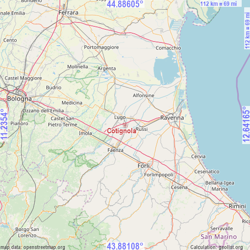
Cotignola GPS coordinates[2]
44° 23' 8.592" North, 11° 56' 18.672" East
| Map corner | latitude | longitude |
|---|---|---|
| Upper-left | 44.88605°, | 11.2354° |
| Center: | 44.38572°, | 11.93852° |
| Lower-right: | 43.88108°, | 12.64165° |
| Map W x H: | 111.7×111.7 km | = 69.4×69.4mi |
| max Lat: | 47.04031° ⇑50.7% North |
| Cotignola: | 44.38572° |
| min Lat: | ⇓49.3% South 35.50142° |
| min Long | Cotignola | max Long |
| 6.69888° | 11.93852° | 18.48682° |
| W 55.1%⇐ | ⇒44.9% E |
Elevation
Elevation of Cotignola is 17 m = 56 ft, and this is 289.7 m = 950 ft below average elevation for this country.
| Max E: |
2085 m = 6841 ft | 90.6% |
| Avg. | 306.7 m = 1006 ft | |
| Cotignola | 17 m = 56 ft | |
Min E: |
-4 m = -13 ft | 9.4% |
See also: Italy elevation on elevation.city.
Geographical zone
Cotignola is located in North temperate zone (between Tropic of Cancer and the Arctic Circle). Distance of this Northern Tropic circle is 2329.3 km =1447.4 mi to South.| Distance of | km | miles | from Cotignola |
|---|---|---|---|
| North Pole | 5071.8 | 3151.5 | to North |
| Arctic Circle | 2465.9 | 1532.2 | to North |
| Tropic Cancer | 2329.3 | 1447.4 | to South |
| Equator | 4935.2 | 3066.6 | to South |


Nearby cities:
15 places around Cotignola: (largest is in red/bold)
• Bagnacavallo
4.5 km =2.8 mi,  45°
45°
• Bagnara di Romagna
8.8 km =5.5 mi,  272°
272°
• Barbiano
4.2 km =2.6 mi,  275°
275°
• Fusignano
9.1 km =5.7 mi,  8°
8°
• Granarolo
3 km =1.9 mi,  185°
185°
• Lugo
4.5 km =2.8 mi,  331°
331°
• Masiera
8.7 km =5.4 mi, 14°
• Mordano
10.5 km =6.5 mi, 276°
• Reda
9.7 km =6 mi,  165°
165°
• Russi
7.6 km =4.7 mi,  97°
97°
• San Potito
5.2 km =3.2 mi,  1°
1°
• Sant'Agata sul Santerno
8.9 km =5.5 mi,  316°
316°
• Santerno
10.9 km =6.8 mi,  58°
58°
• Solarolo
7.9 km =4.9 mi,  247°
247°
• Villa San Martino
6.6 km =4.1 mi,  300°
300°
Sources, notices
• [Note1] Compared only with cities in Italy existing in our database
• [Src1] Map data: © OpenStreetMap contributors (CC-BY-SA)
• [Src2] Other city data from geonames.org with taken over terms of usage.
• [Src3] Geographical zone / Annual Mean Temperature by Robert A. Rohde @ Wikipedia
