Badesi geodata
Badesi (Sardinia) is a seat of a third-order administrative division; located in Italy in Europe/Rome (GMT+2) time zone. With population of 1,342 people, there are 5505 cities with bigger population in this country. Compared to other cities in Italy, 79% of cities are located further ↑North; 83% of cities are located further →East and 73.3% of cities have higher elevation than Badesi. Note1


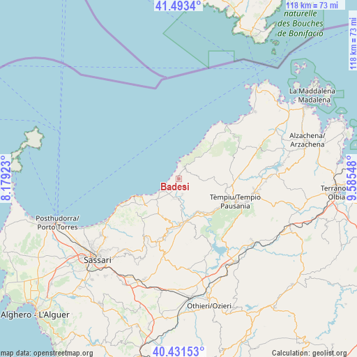
Badesi GPS coordinates[2]
40° 57' 52.56" North, 8° 52' 56.46" East
| Map corner | latitude | longitude |
|---|---|---|
| Upper-left | 41.4934°, | 8.17923° |
| Center: | 40.9646°, | 8.88235° |
| Lower-right: | 40.43153°, | 9.58548° |
| Map W x H: | 118.1×118.1 km | = 73.4×73.4mi |
| max Lat: | 47.04031° ⇑79% North |
| Badesi: | 40.9646° |
| min Lat: | ⇓21% South 35.50142° |
| min Long | Badesi | max Long |
| 6.69888° | 8.88235° | 18.48682° |
| W 17%⇐ | ⇒83% E |
Elevation
Elevation of Badesi is 82 m = 269 ft, and this is 224.7 m = 737 ft below average elevation for this country.
| Max E: |
2085 m = 6841 ft | 73.3% |
| Avg. | 306.7 m = 1006 ft | |
| Badesi | 82 m = 269 ft | |
Min E: |
-4 m = -13 ft | 26.7% |
See also: Italy elevation on elevation.city.
Geographical zone
Badesi is located in North temperate zone (between Tropic of Cancer and the Arctic Circle). Distance of this Northern Tropic circle is 1948.9 km =1211 mi to South.| Distance of | km | miles | from Badesi |
|---|---|---|---|
| North Pole | 5452.2 | 3387.8 | to North |
| Arctic Circle | 2846.3 | 1768.6 | to North |
| Tropic Cancer | 1948.9 | 1211 | to South |
| Equator | 4554.8 | 2830.2 | to South |


Nearby cities:
15 places around Badesi: (largest is in red/bold)
• Aggius
15.8 km =9.8 mi,  104°
104°
• Bortigiadas
15.8 km =9.8 mi,  120°
120°
• Bulzi
13.8 km =8.6 mi,  198°
198°
• Castelsardo
15.2 km =9.4 mi,  247°
247°
• Codaruina
6.3 km =3.9 mi,  230°
230°
• La Muddizza
9.1 km =5.7 mi, 228°
• Laerru
16.9 km =10.5 mi,  193°
193°
• Perfugas
14.7 km =9.1 mi,  179°
179°
• Santa Maria Coghinas
6.9 km =4.3 mi, 193°
• Sedini
13.6 km =8.5 mi, 203°
• Tergu
17.8 km =11.1 mi, 232°
• Trinità d'Agultu
3.5 km =2.2 mi,  48°
48°
• Trinità d'Agultu e Vignola
3.5 km =2.2 mi, 52°
• Valledoria
6.4 km =4 mi, 231°
• Viddalba
5.8 km =3.6 mi,  173°
173°
Sources, notices
• [Note1] Compared only with cities in Italy existing in our database
• [Src1] Map data: © OpenStreetMap contributors (CC-BY-SA)
• [Src2] Other city data from geonames.org with taken over terms of usage.
• [Src3] Geographical zone / Annual Mean Temperature by Robert A. Rohde @ Wikipedia
