Capitan Loreto geodata
Capitan Loreto (Umbria) is a populated place; located in Italy in Europe/Rome (GMT+2) time zone. With population of 1,109 people, there are 6259 cities with bigger population in this country. Compared to other cities in Italy, 63.3% of cities are located further ↑North; 64.2% of cities are located further ←West and 53.6% of cities have higher elevation than Capitan Loreto. Note1


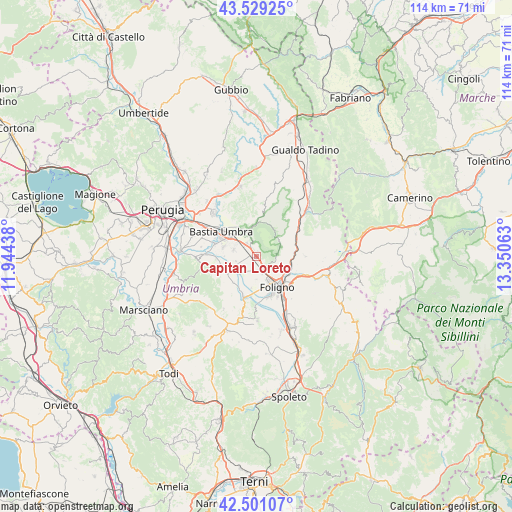
Capitan Loreto GPS coordinates[2]
43° 1' 2.316" North, 12° 38' 51" East
| Map corner | latitude | longitude |
|---|---|---|
| Upper-left | 43.52925°, | 11.94438° |
| Center: | 43.01731°, | 12.6475° |
| Lower-right: | 42.50107°, | 13.35063° |
| Map W x H: | 114.3×114.3 km | = 71×71mi |
| max Lat: | 47.04031° ⇑63.3% North |
| Capitan Loreto: | 43.01731° |
| min Lat: | ⇓36.7% South 35.50142° |
| min Long | Capitan Loreto | max Long |
| 6.69888° | 12.6475° | 18.48682° |
| W 64.2%⇐ | ⇒35.8% E |
Elevation
Elevation of Capitan Loreto is 212 m = 696 ft, and this is 94.7 m = 311 ft below average elevation for this country.
| Max E: |
2085 m = 6841 ft | 53.6% |
| Avg. | 306.7 m = 1006 ft | |
| Capitan Loreto | 212 m = 696 ft | |
Min E: |
-4 m = -13 ft | 46.4% |
See also: Italy elevation on elevation.city.
Geographical zone
Capitan Loreto is located in North temperate zone (between Tropic of Cancer and the Arctic Circle). Distance of this Northern Tropic circle is 2177.2 km =1352.8 mi to South.| Distance of | km | miles | from Capitan Loreto |
|---|---|---|---|
| North Pole | 5224 | 3246 | to North |
| Arctic Circle | 2618.1 | 1626.8 | to North |
| Tropic Cancer | 2177.2 | 1352.8 | to South |
| Equator | 4783.1 | 2972.1 | to South |


Nearby cities:
15 places around Capitan Loreto: (largest is in red/bold)
• Assisi
5.9 km =3.7 mi,  338°
338°
• Bevagna
9.3 km =5.8 mi,  196°
196°
• Cannara
5.9 km =3.7 mi,  245°
245°
• Case Nuove
1.1 km =0.7 mi,  331°
331°
• Castelnuovo
5.3 km =3.3 mi,  284°
284°
• Costano
9.7 km =6 mi,  287°
287°
• Fiamenga
7.1 km =4.4 mi,  170°
170°
• Foligno
8.3 km =5.2 mi,  147°
147°
• Maceratola
7.7 km =4.8 mi, 165°
• Rivotorto
3.7 km =2.3 mi,  323°
323°
• San Vitale
3.3 km =2.1 mi,  346°
346°
• Santa Maria degli Angeli
7.4 km =4.6 mi,  306°
306°
• Spello
3.2 km =2 mi, 151°
• Tordandrea
7.7 km =4.8 mi, 285°
• Valtopina
9.6 km =6 mi,  62°
62°
Sources, notices
• [Note1] Compared only with cities in Italy existing in our database
• [Src1] Map data: © OpenStreetMap contributors (CC-BY-SA)
• [Src2] Other city data from geonames.org with taken over terms of usage.
• [Src3] Geographical zone / Annual Mean Temperature by Robert A. Rohde @ Wikipedia
