Arenzano geodata
Arenzano (Liguria) is a seat of a third-order administrative division; located in Italy in Europe/Rome (GMT+2) time zone. With population of 11,226 people, there are 840 cities with bigger population in this country. Compared to other cities in Italy, 50.3% of cities are located further ↑North; 85.7% of cities are located further →East and 87.4% of cities have higher elevation than Arenzano. Note1


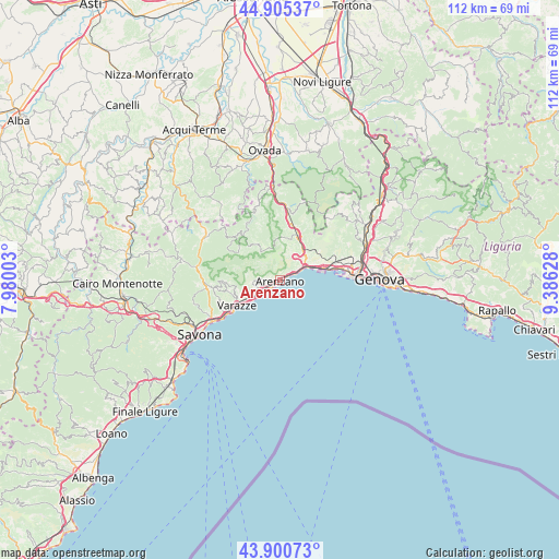
Arenzano GPS coordinates[2]
44° 24' 18.756" North, 8° 40' 59.34" East
| Map corner | latitude | longitude |
|---|---|---|
| Upper-left | 44.90537°, | 7.98003° |
| Center: | 44.40521°, | 8.68315° |
| Lower-right: | 43.90073°, | 9.38628° |
| Map W x H: | 111.7×111.7 km | = 69.4×69.4mi |
| max Lat: | 47.04031° ⇑50.3% North |
| Arenzano: | 44.40521° |
| min Lat: | ⇓49.7% South 35.50142° |
| min Long | Arenzano | max Long |
| 6.69888° | 8.68315° | 18.48682° |
| W 14.3%⇐ | ⇒85.7% E |
Elevation
Elevation of Arenzano is 24 m = 79 ft, and this is 282.7 m = 927 ft below average elevation for this country.
| Max E: |
2085 m = 6841 ft | 87.4% |
| Avg. | 306.7 m = 1006 ft | |
| Arenzano | 24 m = 79 ft | |
Min E: |
-4 m = -13 ft | 12.6% |
See also: Italy elevation on elevation.city.
Geographical zone
Arenzano is located in North temperate zone (between Tropic of Cancer and the Arctic Circle). Distance of this Northern Tropic circle is 2331.5 km =1448.7 mi to South.| Distance of | km | miles | from Arenzano |
|---|---|---|---|
| North Pole | 5069.7 | 3150.2 | to North |
| Arctic Circle | 2463.8 | 1530.9 | to North |
| Tropic Cancer | 2331.5 | 1448.7 | to South |
| Equator | 4937.4 | 3068 | to South |


Nearby cities:
15 places around Arenzano: (largest is in red/bold)
• Campo Ligure
14.7 km =9.1 mi,  4°
4°
• Casavecchia
14.5 km =9 mi,  340°
340°
• Celle Ligure
12.7 km =7.9 mi,  238°
238°
• Cogoleto
3.3 km =2.1 mi, 239°
• Lerca
2.6 km =1.6 mi,  267°
267°
• Masone
11.1 km =6.9 mi,  14°
14°
• Mele
6.9 km =4.3 mi,  49°
49°
• Pero
10.8 km =6.7 mi,  259°
259°
• San Giovanni
14.8 km =9.2 mi, 265°
• San Martino
13.4 km =8.3 mi, 263°
• San Pietro d'Olba
11.8 km =7.3 mi,  320°
320°
• Sciarborasca
5.4 km =3.4 mi, 265°
• Tiglieto
14.1 km =8.8 mi, 338°
• Urbe
11.9 km =7.4 mi, 319°
• Varazze
8.3 km =5.2 mi, 236°
Sources, notices
• [Note1] Compared only with cities in Italy existing in our database
• [Src1] Map data: © OpenStreetMap contributors (CC-BY-SA)
• [Src2] Other city data from geonames.org with taken over terms of usage.
• [Src3] Geographical zone / Annual Mean Temperature by Robert A. Rohde @ Wikipedia
