Mele geodata
Mele (Liguria) is a seat of a third-order administrative division; located in Italy in Europe/Rome (GMT+2) time zone. With population of 1,628 people, there are 4825 cities with bigger population in this country. Compared to other cities in Italy, 50.3% of cities are located further ↓South; 84.8% of cities are located further →East and 65.3% of cities have higher elevation than Mele. Note1


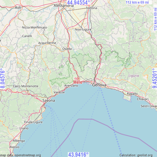
Mele GPS coordinates[2]
44° 26' 44.628" North, 8° 44' 56.004" East
| Map corner | latitude | longitude |
|---|---|---|
| Upper-left | 44.94554°, | 8.04576° |
| Center: | 44.44573°, | 8.74889° |
| Lower-right: | 43.9416°, | 9.45201° |
| Map W x H: | 111.6×111.6 km | = 69.3×69.3mi |
| max Lat: | 47.04031° ⇑49.7% North |
| Mele: | 44.44573° |
| min Lat: | ⇓50.3% South 35.50142° |
| min Long | Mele | max Long |
| 6.69888° | 8.74889° | 18.48682° |
| W 15.2%⇐ | ⇒84.8% E |
Elevation
Elevation of Mele is 126 m = 413 ft, and this is 180.7 m = 593 ft below average elevation for this country.
| Max E: |
2085 m = 6841 ft | 65.3% |
| Avg. | 306.7 m = 1006 ft | |
| Mele | 126 m = 413 ft | |
Min E: |
-4 m = -13 ft | 34.7% |
See also: Italy elevation on elevation.city.
Geographical zone
Mele is located in North temperate zone (between Tropic of Cancer and the Arctic Circle). Distance of this Northern Tropic circle is 2336 km =1451.5 mi to South.| Distance of | km | miles | from Mele |
|---|---|---|---|
| North Pole | 5065.2 | 3147.4 | to North |
| Arctic Circle | 2459.3 | 1528.1 | to North |
| Tropic Cancer | 2336 | 1451.5 | to South |
| Equator | 4941.9 | 3070.8 | to South |


Nearby cities:
15 places around Mele: (largest is in red/bold)
• Arenzano
6.9 km =4.3 mi,  229°
229°
• Campo Ligure
10.9 km =6.8 mi,  338°
338°
• Campomorone
12.9 km =8 mi,  56°
56°
• Ceranesi
13.3 km =8.3 mi, 59°
• Cogoleto
10.2 km =6.3 mi, 232°
• Ferriera-Pontasso
12.6 km =7.8 mi,  53°
53°
• Gaiazza
11.8 km =7.3 mi, 55°
• Isoverde
12.8 km =8 mi,  43°
43°
• Lerca
9.1 km =5.7 mi,  239°
239°
• Masone
6.7 km =4.2 mi, 339°
• San Pietro d'Olba
13.5 km =8.4 mi,  290°
290°
• San Teodoro
13.3 km =8.3 mi,  105°
105°
• Santa Marta
13.1 km =8.1 mi, 60°
• Sciarborasca
11.7 km =7.3 mi,  245°
245°
• Tiglieto
13.4 km =8.3 mi,  309°
309°
Sources, notices
• [Note1] Compared only with cities in Italy existing in our database
• [Src1] Map data: © OpenStreetMap contributors (CC-BY-SA)
• [Src2] Other city data from geonames.org with taken over terms of usage.
• [Src3] Geographical zone / Annual Mean Temperature by Robert A. Rohde @ Wikipedia
