Lerca geodata
Lerca (Liguria) is a populated place; located in Italy in Europe/Rome (GMT+2) time zone. With population of 553 people, there are 9420 cities with bigger population in this country. Compared to other cities in Italy, 50.4% of cities are located further ↑North; 86.1% of cities are located further →East and 69.2% of cities have higher elevation than Lerca. Note1


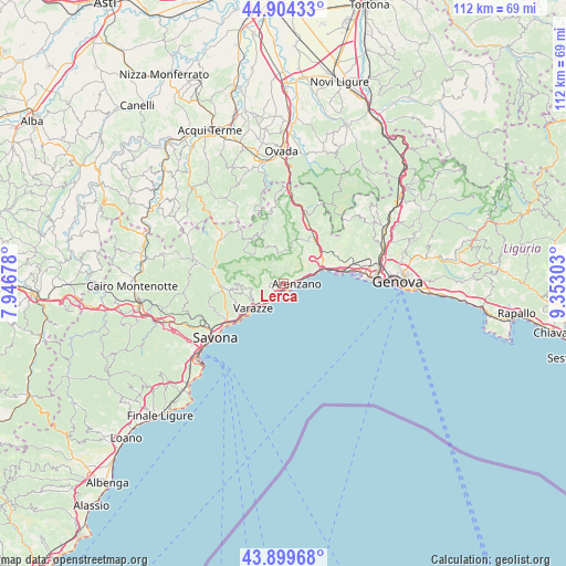
Lerca GPS coordinates[2]
44° 24' 14.976" North, 8° 38' 59.64" East
| Map corner | latitude | longitude |
|---|---|---|
| Upper-left | 44.90433°, | 7.94678° |
| Center: | 44.40416°, | 8.6499° |
| Lower-right: | 43.89968°, | 9.35303° |
| Map W x H: | 111.7×111.7 km | = 69.4×69.4mi |
| max Lat: | 47.04031° ⇑50.4% North |
| Lerca: | 44.40416° |
| min Lat: | ⇓49.6% South 35.50142° |
| min Long | Lerca | max Long |
| 6.69888° | 8.6499° | 18.48682° |
| W 13.9%⇐ | ⇒86.1% E |
Elevation
Elevation of Lerca is 102 m = 335 ft, and this is 204.7 m = 672 ft below average elevation for this country.
| Max E: |
2085 m = 6841 ft | 69.2% |
| Avg. | 306.7 m = 1006 ft | |
| Lerca | 102 m = 335 ft | |
Min E: |
-4 m = -13 ft | 30.8% |
See also: Italy elevation on elevation.city.
Geographical zone
Lerca is located in North temperate zone (between Tropic of Cancer and the Arctic Circle). Distance of this Northern Tropic circle is 2331.4 km =1448.7 mi to South.| Distance of | km | miles | from Lerca |
|---|---|---|---|
| North Pole | 5069.8 | 3150.2 | to North |
| Arctic Circle | 2463.9 | 1531 | to North |
| Tropic Cancer | 2331.4 | 1448.7 | to South |
| Equator | 4937.3 | 3067.9 | to South |


Nearby cities:
15 places around Lerca: (largest is in red/bold)
• Albisola Marina
13.8 km =8.6 mi,  233°
233°
• Albisola Superiore
13.2 km =8.2 mi,  236°
236°
• Arenzano
2.6 km =1.6 mi,  87°
87°
• Celle Ligure
10.5 km =6.5 mi, 231°
• Cogoleto
1.6 km =1 mi,  188°
188°
• Masone
12.1 km =7.5 mi,  26°
26°
• Mele
9.1 km =5.7 mi,  59°
59°
• Pero
8.2 km =5.1 mi,  257°
257°
• San Giovanni
12.2 km =7.6 mi, 264°
• San Martino
10.8 km =6.7 mi, 262°
• San Pietro d'Olba
10.4 km =6.5 mi,  332°
332°
• Sciarborasca
2.8 km =1.7 mi, 264°
• Tiglieto
13.5 km =8.4 mi,  349°
349°
• Urbe
10.5 km =6.5 mi, 331°
• Varazze
6.2 km =3.9 mi,  223°
223°
Sources, notices
• [Note1] Compared only with cities in Italy existing in our database
• [Src1] Map data: © OpenStreetMap contributors (CC-BY-SA)
• [Src2] Other city data from geonames.org with taken over terms of usage.
• [Src3] Geographical zone / Annual Mean Temperature by Robert A. Rohde @ Wikipedia
