Arcene geodata
Arcene (Lombardy) is a seat of a third-order administrative division; located in Italy in Europe/Rome (GMT+2) time zone. With population of 4,556 people, there are 2120 cities with bigger population in this country. Compared to other cities in Italy, 76.1% of cities are located further ↓South; 71.8% of cities are located further →East and 61.3% of cities have higher elevation than Arcene. Note1


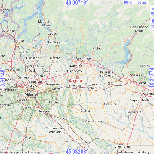
Arcene GPS coordinates[2]
45° 34' 37.812" North, 9° 36' 52.596" East
| Map corner | latitude | longitude |
|---|---|---|
| Upper-left | 46.06716°, | 8.91149° |
| Center: | 45.57717°, | 9.61461° |
| Lower-right: | 45.08286°, | 10.31774° |
| Map W x H: | 109.4×109.4 km | = 68×68mi |
| max Lat: | 47.04031° ⇑23.9% North |
| Arcene: | 45.57717° |
| min Lat: | ⇓76.1% South 35.50142° |
| min Long | Arcene | max Long |
| 6.69888° | 9.61461° | 18.48682° |
| W 28.2%⇐ | ⇒71.8% E |
Elevation
Elevation of Arcene is 153 m = 502 ft, and this is 153.7 m = 504 ft below average elevation for this country.
| Max E: |
2085 m = 6841 ft | 61.3% |
| Avg. | 306.7 m = 1006 ft | |
| Arcene | 153 m = 502 ft | |
Min E: |
-4 m = -13 ft | 38.7% |
See also: Italy elevation on elevation.city.
Geographical zone
Arcene is located in North temperate zone (between Tropic of Cancer and the Arctic Circle). Distance of this North polar circle is 2333.5 km =1450 mi to North.| Distance of | km | miles | from Arcene |
|---|---|---|---|
| North Pole | 4939.4 | 3069.2 | to North |
| Arctic Circle | 2333.5 | 1450 | to North |
| Tropic Cancer | 2461.8 | 1529.7 | to South |
| Equator | 5067.7 | 3148.9 | to South |


Nearby cities:
15 places around Arcene: (largest is in red/bold)
• Boltiere
3.9 km =2.4 mi,  313°
313°
• Brembate
5.6 km =3.5 mi,  303°
303°
• Brignano Gera d'Adda
4.4 km =2.7 mi,  148°
148°
• Canonica d'Adda
5.7 km =3.5 mi,  268°
268°
• Castel Rozzone
2.8 km =1.7 mi,  171°
171°
• Ciserano
1.6 km =1 mi,  318°
318°
• Geromina
5.5 km =3.4 mi,  213°
213°
• Levate
5.4 km =3.4 mi,  7°
7°
• Lurano
2.4 km =1.5 mi,  122°
122°
• Osio Sotto
4.8 km =3 mi,  335°
335°
• Pognano
2.2 km =1.4 mi,  62°
62°
• Pontirolo Nuovo
3.6 km =2.2 mi,  255°
255°
• Spirano
4.2 km =2.6 mi,  83°
83°
• Verdellino
2.7 km =1.7 mi,  349°
349°
• Verdello
3.1 km =1.9 mi,  20°
20°
Sources, notices
• [Note1] Compared only with cities in Italy existing in our database
• [Src1] Map data: © OpenStreetMap contributors (CC-BY-SA)
• [Src2] Other city data from geonames.org with taken over terms of usage.
• [Src3] Geographical zone / Annual Mean Temperature by Robert A. Rohde @ Wikipedia
