Verdellino geodata
Verdellino (Lombardy) is a seat of a third-order administrative division; located in Italy in Europe/Rome (GMT+2) time zone. With population of 7,641 people, there are 1276 cities with bigger population in this country. Compared to other cities in Italy, 77.1% of cities are located further ↓South; 71.9% of cities are located further →East and 59.9% of cities have higher elevation than Verdellino. Note1


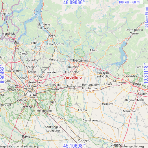
Verdellino GPS coordinates[2]
45° 36' 3.888" North, 9° 36' 28.98" East
| Map corner | latitude | longitude |
|---|---|---|
| Upper-left | 46.09086°, | 8.90492° |
| Center: | 45.60108°, | 9.60805° |
| Lower-right: | 45.10698°, | 10.31118° |
| Map W x H: | 109.4×109.4 km | = 68×68mi |
| max Lat: | 47.04031° ⇑22.9% North |
| Verdellino: | 45.60108° |
| min Lat: | ⇓77.1% South 35.50142° |
| min Long | Verdellino | max Long |
| 6.69888° | 9.60805° | 18.48682° |
| W 28.1%⇐ | ⇒71.9% E |
Elevation
Elevation of Verdellino is 164 m = 538 ft, and this is 142.7 m = 468 ft below average elevation for this country.
| Max E: |
2085 m = 6841 ft | 59.9% |
| Avg. | 306.7 m = 1006 ft | |
| Verdellino | 164 m = 538 ft | |
Min E: |
-4 m = -13 ft | 40.1% |
See also: Italy elevation on elevation.city.
Geographical zone
Verdellino is located in North temperate zone (between Tropic of Cancer and the Arctic Circle). Distance of this North polar circle is 2330.8 km =1448.3 mi to North.| Distance of | km | miles | from Verdellino |
|---|---|---|---|
| North Pole | 4936.7 | 3067.5 | to North |
| Arctic Circle | 2330.8 | 1448.3 | to North |
| Tropic Cancer | 2464.4 | 1531.3 | to South |
| Equator | 5070.4 | 3150.6 | to South |


Nearby cities:
15 places around Verdellino: (largest is in red/bold)
• Arcene
2.7 km =1.7 mi,  169°
169°
• Boltiere
2.3 km =1.4 mi,  269°
269°
• Brembate
4.2 km =2.6 mi,  275°
275°
• Ciserano
1.6 km =1 mi,  200°
200°
• Comun Nuovo
4.8 km =3 mi,  59°
59°
• Dalmine
5.4 km =3.4 mi,  358°
358°
• Levate
3 km =1.9 mi,  25°
25°
• Lurano
4.7 km =2.9 mi,  147°
147°
• Marne
4.6 km =2.9 mi,  303°
303°
• Osio Sopra
3.6 km =2.2 mi,  329°
329°
• Osio Sotto
2.2 km =1.4 mi,  318°
318°
• Pognano
3 km =1.9 mi,  123°
123°
• Pontirolo Nuovo
4.7 km =2.9 mi,  220°
220°
• Spirano
5.2 km =3.2 mi,  114°
114°
• Verdello
1.6 km =1 mi,  79°
79°
Sources, notices
• [Note1] Compared only with cities in Italy existing in our database
• [Src1] Map data: © OpenStreetMap contributors (CC-BY-SA)
• [Src2] Other city data from geonames.org with taken over terms of usage.
• [Src3] Geographical zone / Annual Mean Temperature by Robert A. Rohde @ Wikipedia
