Appignano geodata
Appignano (The Marches) is a seat of a third-order administrative division; located in Italy in Europe/Rome (GMT+2) time zone. With population of 2,987 people, there are 3056 cities with bigger population in this country. Compared to other cities in Italy, 60.7% of cities are located further ↑North; 71.9% of cities are located further ←West and 55.6% of cities have higher elevation than Appignano. Note1


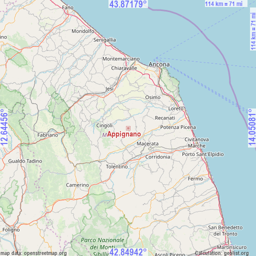
Appignano GPS coordinates[2]
43° 21' 45.936" North, 13° 20' 51.648" East
| Map corner | latitude | longitude |
|---|---|---|
| Upper-left | 43.87179°, | 12.64456° |
| Center: | 43.36276°, | 13.34768° |
| Lower-right: | 42.84942°, | 14.05081° |
| Map W x H: | 113.7×113.7 km | = 70.6×70.6mi |
| max Lat: | 47.04031° ⇑60.7% North |
| Appignano: | 43.36276° |
| min Lat: | ⇓39.3% South 35.50142° |
| min Long | Appignano | max Long |
| 6.69888° | 13.34768° | 18.48682° |
| W 71.9%⇐ | ⇒28.1% E |
Elevation
Elevation of Appignano is 198 m = 650 ft, and this is 108.7 m = 357 ft below average elevation for this country.
| Max E: |
2085 m = 6841 ft | 55.6% |
| Avg. | 306.7 m = 1006 ft | |
| Appignano | 198 m = 650 ft | |
Min E: |
-4 m = -13 ft | 44.4% |
See also: Italy elevation on elevation.city.
Geographical zone
Appignano is located in North temperate zone (between Tropic of Cancer and the Arctic Circle). Distance of this Northern Tropic circle is 2215.6 km =1376.7 mi to South.| Distance of | km | miles | from Appignano |
|---|---|---|---|
| North Pole | 5185.6 | 3222.2 | to North |
| Arctic Circle | 2579.7 | 1603 | to North |
| Tropic Cancer | 2215.6 | 1376.7 | to South |
| Equator | 4821.5 | 2995.9 | to South |


Nearby cities:
15 places around Appignano: (largest is in red/bold)
• Chiesanuova
3.2 km =2 mi,  212°
212°
• Cingoli
11.4 km =7.1 mi,  277°
277°
• Filottrano
8.1 km =5 mi,  2°
2°
• Grottaccia
6.3 km =3.9 mi,  252°
252°
• Macerata
11.2 km =7 mi,  130°
130°
• Montecassiano
7.4 km =4.6 mi,  87°
87°
• Montefano
8.9 km =5.5 mi,  54°
54°
• Montoro
11.6 km =7.2 mi,  27°
27°
• Passo di Treia
8.6 km =5.3 mi,  188°
188°
• Pollenza
10.8 km =6.7 mi,  179°
179°
• Sant'Egidio
9 km =5.6 mi,  101°
101°
• Strada
11.2 km =7 mi,  293°
293°
• Treia
6.7 km =4.2 mi, 206°
• Troviggiano
8.1 km =5 mi, 282°
• Villa Potenza
7.9 km =4.9 mi, 125°
Sources, notices
• [Note1] Compared only with cities in Italy existing in our database
• [Src1] Map data: © OpenStreetMap contributors (CC-BY-SA)
• [Src2] Other city data from geonames.org with taken over terms of usage.
• [Src3] Geographical zone / Annual Mean Temperature by Robert A. Rohde @ Wikipedia
