Treia geodata
Treia (The Marches) is a seat of a third-order administrative division; located in Italy in Europe/Rome (GMT+2) time zone. With population of 2,299 people, there are 3761 cities with bigger population in this country. Compared to other cities in Italy, 61.1% of cities are located further ↑North; 71.5% of cities are located further ←West and 54.4% of cities have lower elevation than Treia. Note1


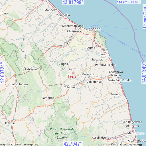
Treia GPS coordinates[2]
43° 18' 30.6" North, 13° 18' 37.296" East
| Map corner | latitude | longitude |
|---|---|---|
| Upper-left | 43.81799°, | 12.60724° |
| Center: | 43.3085°, | 13.31036° |
| Lower-right: | 42.7947°, | 14.01349° |
| Map W x H: | 113.8×113.8 km | = 70.7×70.7mi |
| max Lat: | 47.04031° ⇑61.1% North |
| Treia: | 43.3085° |
| min Lat: | ⇓38.9% South 35.50142° |
| min Long | Treia | max Long |
| 6.69888° | 13.31036° | 18.48682° |
| W 71.5%⇐ | ⇒28.5% E |
Elevation
Elevation of Treia is 262 m = 860 ft, and this is 44.7 m = 147 ft below average elevation for this country.
| Max E: |
2085 m = 6841 ft | 45.6% |
| Avg. | 306.7 m = 1006 ft | |
| Treia | 262 m = 860 ft | |
Min E: |
-4 m = -13 ft | 54.4% |
See also: Italy elevation on elevation.city.
Geographical zone
Treia is located in North temperate zone (between Tropic of Cancer and the Arctic Circle). Distance of this Northern Tropic circle is 2209.5 km =1372.9 mi to South.| Distance of | km | miles | from Treia |
|---|---|---|---|
| North Pole | 5191.6 | 3225.9 | to North |
| Arctic Circle | 2585.7 | 1606.7 | to North |
| Tropic Cancer | 2209.5 | 1372.9 | to South |
| Equator | 4815.5 | 2992.2 | to South |


Nearby cities:
15 places around Treia: (largest is in red/bold)
• Appignano
6.7 km =4.2 mi,  26°
26°
• Casette Verdini
9.8 km =6.1 mi,  130°
130°
• Cesolo
10.8 km =6.7 mi,  240°
240°
• Chiesanuova
3.6 km =2.2 mi,  21°
21°
• Cingoli
11.2 km =7 mi,  312°
312°
• Grottaccia
5.2 km =3.2 mi,  323°
323°
• Macerata
11.6 km =7.2 mi,  95°
95°
• Montecassiano
12.2 km =7.6 mi,  58°
58°
• Passo del Bidollo
11.3 km =7 mi, 126°
• Passo di Treia
3 km =1.9 mi,  143°
143°
• Pollenza
5.6 km =3.5 mi,  147°
147°
• Sforzacosta
10.8 km =6.7 mi,  122°
122°
• Tolentino
11.2 km =7 mi,  190°
190°
• Troviggiano
9.2 km =5.7 mi,  328°
328°
• Villa Potenza
9.5 km =5.9 mi,  81°
81°
Sources, notices
• [Note1] Compared only with cities in Italy existing in our database
• [Src1] Map data: © OpenStreetMap contributors (CC-BY-SA)
• [Src2] Other city data from geonames.org with taken over terms of usage.
• [Src3] Geographical zone / Annual Mean Temperature by Robert A. Rohde @ Wikipedia
