Apecchio geodata
Apecchio (The Marches) is a seat of a third-order administrative division; located in Italy in Europe/Rome (GMT+2) time zone. With population of 1,186 people, there are 6000 cities with bigger population in this country. Compared to other cities in Italy, 59.4% of cities are located further ↑North; 61.5% of cities are located further ←West and 76.9% of cities have lower elevation than Apecchio. Note1
Administrative division(s):
- Level 1: The Marches
- Level 2: Provincia di Pesaro e Urbino
- Level 3: Apecchio


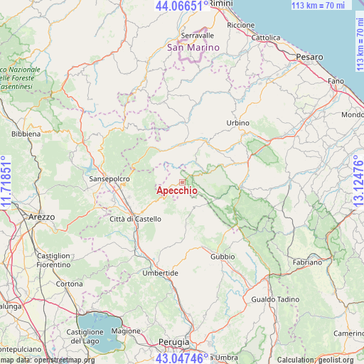
Apecchio GPS coordinates[2]
43° 33' 32.904" North, 12° 25' 17.868" East
| Map corner | latitude | longitude |
|---|---|---|
| Upper-left | 44.06651°, | 11.71851° |
| Center: | 43.55914°, | 12.42163° |
| Lower-right: | 43.04746°, | 13.12476° |
| Map W x H: | 113.3×113.3 km | = 70.4×70.4mi |
| max Lat: | 47.04031° ⇑59.4% North |
| Apecchio: | 43.55914° |
| min Lat: | ⇓40.6% South 35.50142° |
| min Long | Apecchio | max Long |
| 6.69888° | 12.42163° | 18.48682° |
| W 61.5%⇐ | ⇒38.5% E |
Elevation
Elevation of Apecchio is 478 m = 1568 ft, and this is 171.3 m = 562 ft above average elevation for this country.
| Max E: |
2085 m = 6841 ft | 23.1% |
| Apecchio | 478 m 1568 ft | |
| Avg. | 306.7 m = 1006 ft | |
Min E: |
-4 m = -13 ft | 76.9% |
See also: Italy elevation on elevation.city.
Geographical zone
Apecchio is located in North temperate zone (between Tropic of Cancer and the Arctic Circle). Distance of this Northern Tropic circle is 2237.4 km =1390.3 mi to South.| Distance of | km | miles | from Apecchio |
|---|---|---|---|
| North Pole | 5163.7 | 3208.6 | to North |
| Arctic Circle | 2557.9 | 1589.4 | to North |
| Tropic Cancer | 2237.4 | 1390.3 | to South |
| Equator | 4843.3 | 3009.5 | to South |


Nearby cities:
15 places around Apecchio: (largest is in red/bold)
• Belforte
17.9 km =11.1 mi,  348°
348°
• Bellaria-Pole-Petriccio
17.9 km =11.1 mi,  70°
70°
• Borgo Pace
15.1 km =9.4 mi,  316°
316°
• Cagli
18.6 km =11.6 mi,  93°
93°
• Cerbara
18.2 km =11.3 mi,  248°
248°
• Città di Castello
18.1 km =11.2 mi,  234°
234°
• Mercatello sul Metauro
11.9 km =7.4 mi, 324°
• Monte Grimano
10.9 km =6.8 mi,  160°
160°
• Peglio
16.5 km =10.3 mi,  21°
21°
• Piandimeleto
18.3 km =11.4 mi,  356°
356°
• Pietralunga
13.7 km =8.5 mi,  177°
177°
• Piobbico
7.8 km =4.8 mi, 65°
• Sant'Angelo in Vado
11.8 km =7.3 mi, 358°
• Selci-Lama
17.5 km =10.9 mi, 254°
• Urbania
14.5 km =9 mi,  33°
33°
Sources, notices
• [Note1] Compared only with cities in Italy existing in our database
• [Src1] Map data: © OpenStreetMap contributors (CC-BY-SA)
• [Src2] Other city data from geonames.org with taken over terms of usage.
• [Src3] Geographical zone / Annual Mean Temperature by Robert A. Rohde @ Wikipedia
