Pietralunga geodata
Pietralunga (Umbria) is a seat of a third-order administrative division; located in Italy in Europe/Rome (GMT+2) time zone. With population of 1,276 people, there are 5710 cities with bigger population in this country. Compared to other cities in Italy, 60.4% of cities are located further ↑North; 61.6% of cities are located further ←West and 81.7% of cities have lower elevation than Pietralunga. Note1


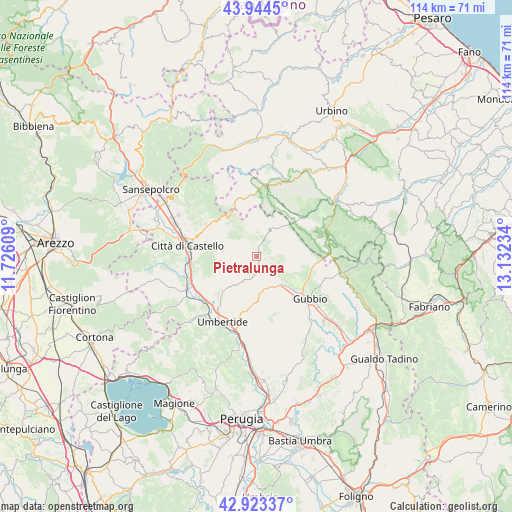
Pietralunga GPS coordinates[2]
43° 26' 9.924" North, 12° 25' 45.156" East
| Map corner | latitude | longitude |
|---|---|---|
| Upper-left | 43.9445°, | 11.72609° |
| Center: | 43.43609°, | 12.42921° |
| Lower-right: | 42.92337°, | 13.13234° |
| Map W x H: | 113.5×113.5 km | = 70.5×70.5mi |
| max Lat: | 47.04031° ⇑60.4% North |
| Pietralunga: | 43.43609° |
| min Lat: | ⇓39.6% South 35.50142° |
| min Long | Pietralunga | max Long |
| 6.69888° | 12.42921° | 18.48682° |
| W 61.6%⇐ | ⇒38.4% E |
Elevation
Elevation of Pietralunga is 548 m = 1798 ft, and this is 241.3 m = 792 ft above average elevation for this country.
| Max E: |
2085 m = 6841 ft | 18.3% |
| Pietralunga | 548 m 1798 ft | |
| Avg. | 306.7 m = 1006 ft | |
Min E: |
-4 m = -13 ft | 81.7% |
See also: Italy elevation on elevation.city.
Geographical zone
Pietralunga is located in North temperate zone (between Tropic of Cancer and the Arctic Circle). Distance of this Northern Tropic circle is 2223.7 km =1381.7 mi to South.| Distance of | km | miles | from Pietralunga |
|---|---|---|---|
| North Pole | 5177.4 | 3217.1 | to North |
| Arctic Circle | 2571.5 | 1597.9 | to North |
| Tropic Cancer | 2223.7 | 1381.7 | to South |
| Equator | 4829.6 | 3001 | to South |


Nearby cities:
15 places around Pietralunga: (largest is in red/bold)
• Apecchio
13.7 km =8.5 mi,  357°
357°
• Cantiano
16.6 km =10.3 mi,  76°
76°
• Cipolleto
17.3 km =10.7 mi,  136°
136°
• Città di Castello
15.8 km =9.8 mi,  281°
281°
• Gubbio
15.1 km =9.4 mi,  129°
129°
• Monte Grimano
4.6 km =2.9 mi,  41°
41°
• Montone
12 km =7.5 mi,  225°
225°
• Piobbico
18.1 km =11.2 mi,  20°
20°
• Ponte d'Assi
18.4 km =11.4 mi, 139°
• Promano
15.1 km =9.4 mi,  239°
239°
• San Secondo
16.2 km =10.1 mi,  257°
257°
• Semonte-Casamorcia
11.1 km =6.9 mi, 132°
• Trestina
17.4 km =10.8 mi, 243°
• Umbertide
16.5 km =10.3 mi,  206°
206°
• Verna
17.9 km =11.1 mi, 239°
Sources, notices
• [Note1] Compared only with cities in Italy existing in our database
• [Src1] Map data: © OpenStreetMap contributors (CC-BY-SA)
• [Src2] Other city data from geonames.org with taken over terms of usage.
• [Src3] Geographical zone / Annual Mean Temperature by Robert A. Rohde @ Wikipedia
