Chiassa-Tregozzano geodata
Chiassa-Tregozzano (Tuscany) is a populated locality; located in Italy in Europe/Rome (GMT+2) time zone. With population of 1,767 people, there are 4543 cities with bigger population in this country. Compared to other cities in Italy, 59.7% of cities are located further ↑North; 54.4% of cities are located further ←West and 58.4% of cities have lower elevation than Chiassa-Tregozzano. Note1


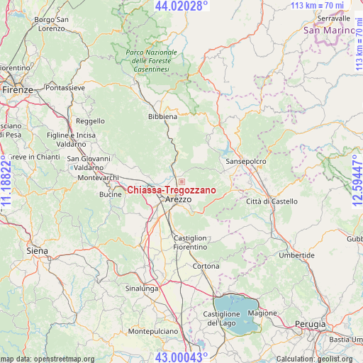
Chiassa-Tregozzano GPS coordinates[2]
43° 30' 45.036" North, 11° 53' 28.824" East
| Map corner | latitude | longitude |
|---|---|---|
| Upper-left | 44.02028°, | 11.18822° |
| Center: | 43.51251°, | 11.89134° |
| Lower-right: | 43.00043°, | 12.59447° |
| Map W x H: | 113.4×113.4 km | = 70.5×70.5mi |
| max Lat: | 47.04031° ⇑59.7% North |
| Chiassa-Tregozzano: | 43.51251° |
| min Lat: | ⇓40.3% South 35.50142° |
| min Long | Chiassa-Tregozz | max Long |
| 6.69888° | 11.89134° | 18.48682° |
| W 54.4%⇐ | ⇒45.6% E |
Elevation
Elevation of Chiassa-Tregozzano is 288 m = 945 ft, and this is 18.7 m = 61 ft below average elevation for this country.
| Max E: |
2085 m = 6841 ft | 41.6% |
| Avg. | 306.7 m = 1006 ft | |
| Chiassa-Tregozzano | 288 m = 945 ft | |
Min E: |
-4 m = -13 ft | 58.4% |
See also: Italy elevation on elevation.city.
Geographical zone
Chiassa-Tregozzano is located in North temperate zone (between Tropic of Cancer and the Arctic Circle). Distance of this Northern Tropic circle is 2232.2 km =1387 mi to South.| Distance of | km | miles | from Chiassa-Tregozzano |
|---|---|---|---|
| North Pole | 5168.9 | 3211.8 | to North |
| Arctic Circle | 2563 | 1592.6 | to North |
| Tropic Cancer | 2232.2 | 1387 | to South |
| Equator | 4838.1 | 3006.3 | to South |


Nearby cities:
15 places around Chiassa-Tregozzano: (largest is in red/bold)
• Anghiari
13.8 km =8.6 mi,  76°
76°
• Arezzo
5.6 km =3.5 mi,  188°
188°
• Battifolle-Ruscello-Poggiola
10.1 km =6.3 mi,  226°
226°
• Capolona
6.4 km =4 mi,  339°
339°
• Castelluccio
4.8 km =3 mi,  284°
284°
• Castiglion Fibocchi
10.6 km =6.6 mi, 278°
• Giovi-Ponte alla Chiassa
2.6 km =1.6 mi,  306°
306°
• Palazzo del Pero
12.3 km =7.6 mi,  146°
146°
• Pieve al Toppo
13.9 km =8.6 mi,  213°
213°
• Pitigliano
7.7 km =4.8 mi, 154°
• Pratantico-Indicatore
7.8 km =4.8 mi,  242°
242°
• Quarata
5.4 km =3.4 mi,  253°
253°
• Subbiano
7.5 km =4.7 mi,  347°
347°
• Talla
13 km =8.1 mi,  319°
319°
• Viciomaggio
13.1 km =8.1 mi, 226°
Sources, notices
• [Note1] Compared only with cities in Italy existing in our database
• [Src1] Map data: © OpenStreetMap contributors (CC-BY-SA)
• [Src2] Other city data from geonames.org with taken over terms of usage.
• [Src3] Geographical zone / Annual Mean Temperature by Robert A. Rohde @ Wikipedia
