Sarnano geodata
Sarnano (The Marches) is a seat of a third-order administrative division; located in Italy in Europe/Rome (GMT+2) time zone. With population of 1,883 people, there are 4348 cities with bigger population in this country. Compared to other cities in Italy, 63.1% of cities are located further ↑North; 71.3% of cities are located further ←West and 79.3% of cities have lower elevation than Sarnano. Note1


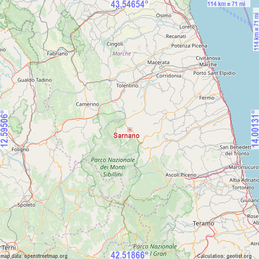
Sarnano GPS coordinates[2]
43° 2' 5.1" North, 13° 17' 53.448" East
| Map corner | latitude | longitude |
|---|---|---|
| Upper-left | 43.54654°, | 12.59506° |
| Center: | 43.03475°, | 13.29818° |
| Lower-right: | 42.51866°, | 14.00131° |
| Map W x H: | 114.3×114.3 km | = 71×71mi |
| max Lat: | 47.04031° ⇑63.1% North |
| Sarnano: | 43.03475° |
| min Lat: | ⇓36.9% South 35.50142° |
| min Long | Sarnano | max Long |
| 6.69888° | 13.29818° | 18.48682° |
| W 71.3%⇐ | ⇒28.7% E |
Elevation
Elevation of Sarnano is 514 m = 1686 ft, and this is 207.3 m = 680 ft above average elevation for this country.
| Max E: |
2085 m = 6841 ft | 20.7% |
| Sarnano | 514 m 1686 ft | |
| Avg. | 306.7 m = 1006 ft | |
Min E: |
-4 m = -13 ft | 79.3% |
See also: Italy elevation on elevation.city.
Geographical zone
Sarnano is located in North temperate zone (between Tropic of Cancer and the Arctic Circle). Distance of this Northern Tropic circle is 2179.1 km =1354 mi to South.| Distance of | km | miles | from Sarnano |
|---|---|---|---|
| North Pole | 5222 | 3244.8 | to North |
| Arctic Circle | 2616.2 | 1625.6 | to North |
| Tropic Cancer | 2179.1 | 1354 | to South |
| Equator | 4785 | 2973.3 | to South |


Nearby cities:
15 places around Sarnano: (largest is in red/bold)
• Amandola
7.8 km =4.8 mi,  143°
143°
• Bolognola
7.4 km =4.6 mi,  231°
231°
• Camporotondo di Fiastrone
11.1 km =6.9 mi,  346°
346°
• Cessapalombo
8.8 km =5.5 mi,  338°
338°
• Comunanza
12.7 km =7.9 mi,  132°
132°
• Gualdo
5 km =3.1 mi,  46°
46°
• Monte San Martino
11.6 km =7.2 mi,  91°
91°
• Monte Vidon Combatte
12.3 km =7.6 mi, 90°
• Montefortino
10.8 km =6.7 mi,  159°
159°
• Penna San Giovanni
10.6 km =6.6 mi,  77°
77°
• Pie' del Colle
10 km =6.2 mi,  266°
266°
• San Ginesio
8.3 km =5.2 mi,  13°
13°
• Sant'Angelo in Pontano
10.7 km =6.6 mi, 48°
• Smerillo
12.4 km =7.7 mi,  105°
105°
• Trebbio
11.7 km =7.3 mi, 271°
Sources, notices
• [Note1] Compared only with cities in Italy existing in our database
• [Src1] Map data: © OpenStreetMap contributors (CC-BY-SA)
• [Src2] Other city data from geonames.org with taken over terms of usage.
• [Src3] Geographical zone / Annual Mean Temperature by Robert A. Rohde @ Wikipedia
