Bolognola geodata
Bolognola (The Marches) is a seat of a third-order administrative division; located in Italy in Europe/Rome (GMT+2) time zone. With population of 140 people, there are 11313 cities with bigger population in this country. Compared to other cities in Italy, 63.5% of cities are located further ↑North; 70.6% of cities are located further ←West and 97.5% of cities have lower elevation than Bolognola. Note1


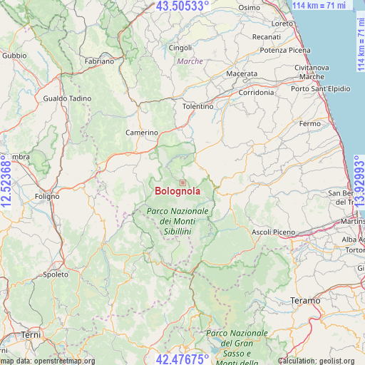
Bolognola GPS coordinates[2]
42° 59' 35.484" North, 13° 13' 36.48" East
| Map corner | latitude | longitude |
|---|---|---|
| Upper-left | 43.50533°, | 12.52368° |
| Center: | 42.99319°, | 13.2268° |
| Lower-right: | 42.47675°, | 13.92993° |
| Map W x H: | 114.4×114.4 km | = 71.1×71.1mi |
| max Lat: | 47.04031° ⇑63.5% North |
| Bolognola: | 42.99319° |
| min Lat: | ⇓36.5% South 35.50142° |
| min Long | Bolognola | max Long |
| 6.69888° | 13.2268° | 18.48682° |
| W 70.6%⇐ | ⇒29.4% E |
Elevation
Elevation of Bolognola is 1038 m = 3406 ft, and this is 731.3 m = 2399 ft above average elevation for this country.
| Max E: |
2085 m = 6841 ft | 2.5% |
| Bolognola | 1038 m 3406 ft | |
| Avg. | 306.7 m = 1006 ft | |
Min E: |
-4 m = -13 ft | 97.5% |
See also: Italy elevation on elevation.city.
Geographical zone
Bolognola is located in North temperate zone (between Tropic of Cancer and the Arctic Circle). Distance of this Northern Tropic circle is 2174.5 km =1351.2 mi to South.| Distance of | km | miles | from Bolognola |
|---|---|---|---|
| North Pole | 5226.7 | 3247.7 | to North |
| Arctic Circle | 2620.8 | 1628.5 | to North |
| Tropic Cancer | 2174.5 | 1351.2 | to South |
| Equator | 4780.4 | 2970.4 | to South |


Nearby cities:
15 places around Bolognola: (largest is in red/bold)
• Amandola
10.5 km =6.5 mi,  99°
99°
• Castelsantangelo sul Nera
12.5 km =7.8 mi,  207°
207°
• Cessapalombo
13 km =8.1 mi,  11°
11°
• Fluminata
9.3 km =5.8 mi,  233°
233°
• Gualdo
12.4 km =7.7 mi,  49°
49°
• Montefortino
11 km =6.8 mi,  120°
120°
• Montemonaco
13.5 km =8.4 mi,  141°
141°
• Pie' del Colle
5.8 km =3.6 mi,  314°
314°
• Pieve Torina
15.6 km =9.7 mi,  290°
290°
• Pievebovigliana
14 km =8.7 mi,  303°
303°
• San Ginesio
14.8 km =9.2 mi,  31°
31°
• Sarnano
7.4 km =4.6 mi, 51°
• Trebbio
7.7 km =4.8 mi, 309°
• Valle e Castello
12.4 km =7.7 mi, 293°
• Visso
13.6 km =8.5 mi,  240°
240°
Sources, notices
• [Note1] Compared only with cities in Italy existing in our database
• [Src1] Map data: © OpenStreetMap contributors (CC-BY-SA)
• [Src2] Other city data from geonames.org with taken over terms of usage.
• [Src3] Geographical zone / Annual Mean Temperature by Robert A. Rohde @ Wikipedia
