Gualdo geodata
Gualdo (The Marches) is a seat of a third-order administrative division; located in Italy in Europe/Rome (GMT+2) time zone. With population of 371 people, there are 10388 cities with bigger population in this country. Compared to other cities in Italy, 62.8% of cities are located further ↑North; 71.9% of cities are located further ←West and 84.7% of cities have lower elevation than Gualdo. Note1


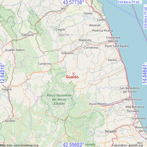
Gualdo GPS coordinates[2]
43° 3' 57.06" North, 13° 20' 35.808" East
| Map corner | latitude | longitude |
|---|---|---|
| Upper-left | 43.57738°, | 12.64016° |
| Center: | 43.06585°, | 13.34328° |
| Lower-right: | 42.55002°, | 14.04641° |
| Map W x H: | 114.2×114.2 km | = 71×71mi |
| max Lat: | 47.04031° ⇑62.8% North |
| Gualdo: | 43.06585° |
| min Lat: | ⇓37.2% South 35.50142° |
| min Long | Gualdo | max Long |
| 6.69888° | 13.34328° | 18.48682° |
| W 71.9%⇐ | ⇒28.1% E |
Elevation
Elevation of Gualdo is 604 m = 1982 ft, and this is 297.3 m = 975 ft above average elevation for this country.
| Max E: |
2085 m = 6841 ft | 15.3% |
| Gualdo | 604 m 1982 ft | |
| Avg. | 306.7 m = 1006 ft | |
Min E: |
-4 m = -13 ft | 84.7% |
See also: Italy elevation on elevation.city.
Geographical zone
Gualdo is located in North temperate zone (between Tropic of Cancer and the Arctic Circle). Distance of this Northern Tropic circle is 2182.6 km =1356.2 mi to South.| Distance of | km | miles | from Gualdo |
|---|---|---|---|
| North Pole | 5218.6 | 3242.7 | to North |
| Arctic Circle | 2612.7 | 1623.5 | to North |
| Tropic Cancer | 2182.6 | 1356.2 | to South |
| Equator | 4788.5 | 2975.4 | to South |


Nearby cities:
15 places around Gualdo: (largest is in red/bold)
• Amandola
9.8 km =6.1 mi,  174°
174°
• Camporotondo di Fiastrone
9.7 km =6 mi,  319°
319°
• Cessapalombo
8.4 km =5.2 mi,  304°
304°
• Colmurano
11.1 km =6.9 mi,  6°
6°
• Falerone
11.3 km =7 mi,  67°
67°
• Loro Piceno
12.3 km =7.6 mi,  26°
26°
• Monte San Martino
8.7 km =5.4 mi,  115°
115°
• Monte Vidon Combatte
9.4 km =5.8 mi,  112°
112°
• Penna San Giovanni
6.8 km =4.2 mi,  99°
99°
• Ripe San Ginesio
8.7 km =5.4 mi, 12°
• San Ginesio
5 km =3.1 mi,  338°
338°
• Sant'Angelo in Pontano
5.6 km =3.5 mi,  50°
50°
• Sarnano
5 km =3.1 mi,  226°
226°
• Servigliano
12.2 km =7.6 mi,  82°
82°
• Smerillo
10.7 km =6.6 mi,  129°
129°
Sources, notices
• [Note1] Compared only with cities in Italy existing in our database
• [Src1] Map data: © OpenStreetMap contributors (CC-BY-SA)
• [Src2] Other city data from geonames.org with taken over terms of usage.
• [Src3] Geographical zone / Annual Mean Temperature by Robert A. Rohde @ Wikipedia
