Alvito geodata
Alvito (Latium) is a seat of a third-order administrative division; located in Italy in Europe/Rome (GMT+2) time zone. With population of 988 people, there are 6718 cities with bigger population in this country. Compared to other cities in Italy, 73% of cities are located further ↑North; 76.1% of cities are located further ←West and 77.2% of cities have lower elevation than Alvito. Note1


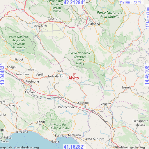
Alvito GPS coordinates[2]
41° 41' 24.072" North, 13° 44' 52.62" East
| Map corner | latitude | longitude |
|---|---|---|
| Upper-left | 42.21294°, | 13.04483° |
| Center: | 41.69002°, | 13.74795° |
| Lower-right: | 41.16282°, | 14.45108° |
| Map W x H: | 116.8×116.8 km | = 72.6×72.6mi |
| max Lat: | 47.04031° ⇑73% North |
| Alvito: | 41.69002° |
| min Lat: | ⇓27% South 35.50142° |
| min Long | Alvito | max Long |
| 6.69888° | 13.74795° | 18.48682° |
| W 76.1%⇐ | ⇒23.9% E |
Elevation
Elevation of Alvito is 482 m = 1581 ft, and this is 175.3 m = 575 ft above average elevation for this country.
| Max E: |
2085 m = 6841 ft | 22.8% |
| Alvito | 482 m 1581 ft | |
| Avg. | 306.7 m = 1006 ft | |
Min E: |
-4 m = -13 ft | 77.2% |
See also: Italy elevation on elevation.city.
Geographical zone
Alvito is located in North temperate zone (between Tropic of Cancer and the Arctic Circle). Distance of this Northern Tropic circle is 2029.6 km =1261.1 mi to South.| Distance of | km | miles | from Alvito |
|---|---|---|---|
| North Pole | 5371.6 | 3337.8 | to North |
| Arctic Circle | 2765.7 | 1718.5 | to North |
| Tropic Cancer | 2029.6 | 1261.1 | to South |
| Equator | 4635.5 | 2880.4 | to South |


Nearby cities:
15 places around Alvito: (largest is in red/bold)
• Atina
8.9 km =5.5 mi,  151°
151°
• Atina Inferiore
7.9 km =4.9 mi, 152°
• Broccostella
9.4 km =5.8 mi,  276°
276°
• Campoli Appennino
7.4 km =4.6 mi,  313°
313°
• Casalattico
7.8 km =4.8 mi,  193°
193°
• Casalvieri
6.9 km =4.3 mi,  204°
204°
• Fontechiari
6.5 km =4 mi,  247°
247°
• Gallinaro
5.7 km =3.5 mi,  133°
133°
• Pescosolido
10 km =6.2 mi, 310°
• Picinisco
11.1 km =6.9 mi,  116°
116°
• Posta Fibreno
5.6 km =3.5 mi,  272°
272°
• San Donato Val di Comino
5.7 km =3.5 mi,  70°
70°
• Settefrati
8.8 km =5.5 mi,  104°
104°
• Vicalvi
3.6 km =2.2 mi, 248°
• Villa Latina
11.1 km =6.9 mi,  138°
138°
Sources, notices
• [Note1] Compared only with cities in Italy existing in our database
• [Src1] Map data: © OpenStreetMap contributors (CC-BY-SA)
• [Src2] Other city data from geonames.org with taken over terms of usage.
• [Src3] Geographical zone / Annual Mean Temperature by Robert A. Rohde @ Wikipedia
