Alghero geodata
Alghero (Sardinia) is a seat of a third-order administrative division; located in Italy in Europe/Rome (GMT+2) time zone. With population of 34,261 people, there are 223 cities with bigger population in this country. Compared to other cities in Italy, 83.7% of cities are located further ↑North; 89.9% of cities are located further →East and 90.1% of cities have higher elevation than Alghero. Note1


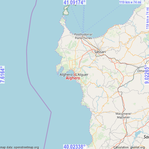
Alghero GPS coordinates[2]
40° 33' 34.884" North, 8° 19' 10.308" East
| Map corner | latitude | longitude |
|---|---|---|
| Upper-left | 41.09174°, | 7.6164° |
| Center: | 40.55969°, | 8.31953° |
| Lower-right: | 40.02338°, | 9.02265° |
| Map W x H: | 118.8×118.8 km | = 73.8×73.8mi |
| max Lat: | 47.04031° ⇑83.7% North |
| Alghero: | 40.55969° |
| min Lat: | ⇓16.3% South 35.50142° |
| min Long | Alghero | max Long |
| 6.69888° | 8.31953° | 18.48682° |
| W 10.1%⇐ | ⇒89.9% E |
Elevation
Elevation of Alghero is 18 m = 59 ft, and this is 288.7 m = 947 ft below average elevation for this country.
| Max E: |
2085 m = 6841 ft | 90.1% |
| Avg. | 306.7 m = 1006 ft | |
| Alghero | 18 m = 59 ft | |
Min E: |
-4 m = -13 ft | 9.9% |
See also: Italy elevation on elevation.city.
Geographical zone
Alghero is located in North temperate zone (between Tropic of Cancer and the Arctic Circle). Distance of this Northern Tropic circle is 1903.9 km =1183 mi to South.| Distance of | km | miles | from Alghero |
|---|---|---|---|
| North Pole | 5497.2 | 3415.8 | to North |
| Arctic Circle | 2891.4 | 1796.6 | to North |
| Tropic Cancer | 1903.9 | 1183 | to South |
| Equator | 4509.8 | 2802.3 | to South |


Nearby cities:
15 places around Alghero: (largest is in red/bold)
• Bancali
23 km =14.3 mi,  31°
31°
• Fertilia
4.9 km =3 mi,  320°
320°
• Ittiri
21.4 km =13.3 mi,  80°
80°
• Li Punti-San Giovanni
26.8 km =16.7 mi, 32°
• Monteleone Rocca Doria
22.6 km =14 mi,  115°
115°
• Montresta
25.7 km =16 mi,  143°
143°
• Olmedo
11.4 km =7.1 mi, 26°
• Ossi
26.4 km =16.4 mi,  60°
60°
• Putifigari
11.9 km =7.4 mi,  89°
89°
• Romana
24 km =14.9 mi,  110°
110°
• Sassari
27.2 km =16.9 mi,  47°
47°
• Tissi
24.3 km =15.1 mi, 57°
• Uri
16.8 km =10.4 mi, 58°
• Usini
21.9 km =13.6 mi, 57°
• Villanova Monteleone
14.3 km =8.9 mi, 116°
Sources, notices
• [Note1] Compared only with cities in Italy existing in our database
• [Src1] Map data: © OpenStreetMap contributors (CC-BY-SA)
• [Src2] Other city data from geonames.org with taken over terms of usage.
• [Src3] Geographical zone / Annual Mean Temperature by Robert A. Rohde @ Wikipedia
