Bancali geodata
Bancali (Sardinia) is a populated place; located in Italy in Europe/Rome (GMT+2) time zone. With population of 1,345 people, there are 5498 cities with bigger population in this country. Compared to other cities in Italy, 82.1% of cities are located further ↑North; 88.3% of cities are located further →East and 72.8% of cities have higher elevation than Bancali. Note1


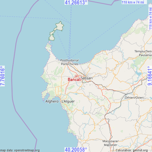
Bancali GPS coordinates[2]
40° 44' 7.764" North, 8° 27' 47.808" East
| Map corner | latitude | longitude |
|---|---|---|
| Upper-left | 41.26613°, | 7.76016° |
| Center: | 40.73549°, | 8.46328° |
| Lower-right: | 40.20058°, | 9.16641° |
| Map W x H: | 118.5×118.5 km | = 73.6×73.6mi |
| max Lat: | 47.04031° ⇑82.1% North |
| Bancali: | 40.73549° |
| min Lat: | ⇓17.9% South 35.50142° |
| min Long | Bancali | max Long |
| 6.69888° | 8.46328° | 18.48682° |
| W 11.7%⇐ | ⇒88.3% E |
Elevation
Elevation of Bancali is 84 m = 276 ft, and this is 222.7 m = 731 ft below average elevation for this country.
| Max E: |
2085 m = 6841 ft | 72.8% |
| Avg. | 306.7 m = 1006 ft | |
| Bancali | 84 m = 276 ft | |
Min E: |
-4 m = -13 ft | 27.2% |
See also: Italy elevation on elevation.city.
Geographical zone
Bancali is located in North temperate zone (between Tropic of Cancer and the Arctic Circle). Distance of this Northern Tropic circle is 1923.4 km =1195.1 mi to South.| Distance of | km | miles | from Bancali |
|---|---|---|---|
| North Pole | 5477.7 | 3403.7 | to North |
| Arctic Circle | 2871.8 | 1784.5 | to North |
| Tropic Cancer | 1923.4 | 1195.1 | to South |
| Equator | 4529.4 | 2814.4 | to South |


Nearby cities:
15 places around Bancali: (largest is in red/bold)
• Cargeghe
14.8 km =9.2 mi,  120°
120°
• Ittiri
18.4 km =11.4 mi,  150°
150°
• Li Punti-San Giovanni
3.8 km =2.4 mi,  34°
34°
• Muros
14.5 km =9 mi, 115°
• Olmedo
11.7 km =7.3 mi,  216°
216°
• Osilo
17.5 km =10.9 mi,  87°
87°
• Ossi
12.8 km =8 mi, 121°
• Ottava
5.6 km =3.5 mi,  10°
10°
• Porto Torres
12 km =7.5 mi,  335°
335°
• Sassari
7.8 km =4.8 mi,  97°
97°
• Sennori
12.4 km =7.7 mi,  61°
61°
• Sorso
11.8 km =7.3 mi,  53°
53°
• Tissi
10.4 km =6.5 mi,  127°
127°
• Uri
11 km =6.8 mi,  168°
168°
• Usini
10.2 km =6.3 mi,  141°
141°
Sources, notices
• [Note1] Compared only with cities in Italy existing in our database
• [Src1] Map data: © OpenStreetMap contributors (CC-BY-SA)
• [Src2] Other city data from geonames.org with taken over terms of usage.
• [Src3] Geographical zone / Annual Mean Temperature by Robert A. Rohde @ Wikipedia
