Sassari geodata
Sassari (Sardinia) is a seat of a second-order administrative division; located in Italy in Europe/Rome (GMT+2) time zone. With population of 91,895 people, there are 43 cities with bigger population in this country. Compared to other cities in Italy, 82.2% of cities are located further ↑North; 87.3% of cities are located further →East and 56.7% of cities have higher elevation than Sassari. Note1


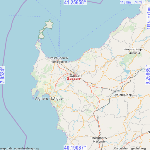
Sassari GPS coordinates[2]
40° 43' 33.096" North, 8° 33' 19.872" East
| Map corner | latitude | longitude |
|---|---|---|
| Upper-left | 41.25658°, | 7.8524° |
| Center: | 40.72586°, | 8.55552° |
| Lower-right: | 40.19087°, | 9.25865° |
| Map W x H: | 118.5×118.5 km | = 73.6×73.6mi |
| max Lat: | 47.04031° ⇑82.2% North |
| Sassari: | 40.72586° |
| min Lat: | ⇓17.8% South 35.50142° |
| min Long | Sassari | max Long |
| 6.69888° | 8.55552° | 18.48682° |
| W 12.7%⇐ | ⇒87.3% E |
Elevation
Elevation of Sassari is 190 m = 623 ft, and this is 116.7 m = 383 ft below average elevation for this country.
| Max E: |
2085 m = 6841 ft | 56.7% |
| Avg. | 306.7 m = 1006 ft | |
| Sassari | 190 m = 623 ft | |
Min E: |
-4 m = -13 ft | 43.3% |
See also: Sassari elevation on elevation.city.
Geographical zone
Sassari is located in North temperate zone (between Tropic of Cancer and the Arctic Circle). Distance of this Northern Tropic circle is 1922.4 km =1194.5 mi to South.| Distance of | km | miles | from Sassari |
|---|---|---|---|
| North Pole | 5478.8 | 3404.4 | to North |
| Arctic Circle | 2872.9 | 1785.1 | to North |
| Tropic Cancer | 1922.4 | 1194.5 | to South |
| Equator | 4528.3 | 2813.8 | to South |


Nearby cities:
15 places around Sassari: (largest is in red/bold)
• Bancali
7.8 km =4.8 mi,  277°
277°
• Cargeghe
8.1 km =5 mi,  141°
141°
• Codrongianos
13.1 km =8.1 mi,  126°
126°
• Florinas
12.6 km =7.8 mi, 132°
• Ittiri
15 km =9.3 mi,  175°
175°
• Li Punti-San Giovanni
7 km =4.3 mi,  306°
306°
• Muros
7.4 km =4.6 mi, 134°
• Osilo
9.9 km =6.2 mi,  78°
78°
• Ossi
6.5 km =4 mi,  151°
151°
• Ottava
9.4 km =5.8 mi, 314°
• Sennori
7.6 km =4.7 mi,  24°
24°
• Sorso
8.4 km =5.2 mi,  11°
11°
• Tissi
5.3 km =3.3 mi,  174°
174°
• Uri
11.2 km =7 mi,  210°
210°
• Usini
7 km =4.3 mi,  191°
191°
Sources, notices
• [Note1] Compared only with cities in Italy existing in our database
• [Src1] Map data: © OpenStreetMap contributors (CC-BY-SA)
• [Src2] Other city data from geonames.org with taken over terms of usage.
• [Src3] Geographical zone / Annual Mean Temperature by Robert A. Rohde @ Wikipedia
