Albignasego geodata
Albignasego (Veneto) is a seat of a third-order administrative division; located in Italy in Europe/Rome (GMT+2) time zone. With population of 16,477 people, there are 553 cities with bigger population in this country. Compared to other cities in Italy, 68.7% of cities are located further ↓South; 54.1% of cities are located further ←West and 93.6% of cities have higher elevation than Albignasego. Note1


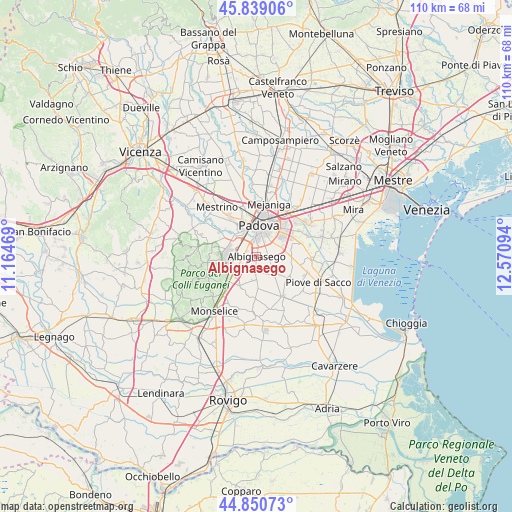
Albignasego GPS coordinates[2]
45° 20' 49.38" North, 11° 52' 4.116" East
| Map corner | latitude | longitude |
|---|---|---|
| Upper-left | 45.83906°, | 11.16469° |
| Center: | 45.34705°, | 11.86781° |
| Lower-right: | 44.85073°, | 12.57094° |
| Map W x H: | 109.9×109.9 km | = 68.3×68.3mi |
| max Lat: | 47.04031° ⇑31.3% North |
| Albignasego: | 45.34705° |
| min Lat: | ⇓68.7% South 35.50142° |
| min Long | Albignasego | max Long |
| 6.69888° | 11.86781° | 18.48682° |
| W 54.1%⇐ | ⇒45.9% E |
Elevation
Elevation of Albignasego is 11 m = 36 ft, and this is 295.7 m = 970 ft below average elevation for this country.
| Max E: |
2085 m = 6841 ft | 93.6% |
| Avg. | 306.7 m = 1006 ft | |
| Albignasego | 11 m = 36 ft | |
Min E: |
-4 m = -13 ft | 6.4% |
See also: Italy elevation on elevation.city.
Geographical zone
Albignasego is located in North temperate zone (between Tropic of Cancer and the Arctic Circle). Distance of this North polar circle is 2359.1 km =1465.9 mi to North.| Distance of | km | miles | from Albignasego |
|---|---|---|---|
| North Pole | 4964.9 | 3085 | to North |
| Arctic Circle | 2359.1 | 1465.9 | to North |
| Tropic Cancer | 2436.2 | 1513.8 | to South |
| Equator | 5042.1 | 3133 | to South |


Nearby cities:
15 places around Albignasego: (largest is in red/bold)
• Abano Terme
6.4 km =4 mi,  280°
280°
• Bertipaglia
3.7 km =2.3 mi,  158°
158°
• Cagnola
7.2 km =4.5 mi,  179°
179°
• Casalserugo
4.9 km =3 mi,  135°
135°
• Cornegliana
5.1 km =3.2 mi,  193°
193°
• Due Carrare
7.1 km =4.4 mi,  209°
209°
• Mandriola-Sant'Agostino
2.8 km =1.7 mi,  332°
332°
• Maserà di Padova
3.2 km =2 mi, 183°
• Mezzavia
5.2 km =3.2 mi,  238°
238°
• Montegrotto Terme
6.6 km =4.1 mi,  254°
254°
• Padova
6.9 km =4.3 mi,  11°
11°
• Ponte San Nicolò
4.9 km =3 mi,  62°
62°
• Roncajette
5.4 km =3.4 mi,  92°
92°
• Tencarola
7 km =4.3 mi,  319°
319°
• Terradura
4.3 km =2.7 mi,  231°
231°
Sources, notices
• [Note1] Compared only with cities in Italy existing in our database
• [Src1] Map data: © OpenStreetMap contributors (CC-BY-SA)
• [Src2] Other city data from geonames.org with taken over terms of usage.
• [Src3] Geographical zone / Annual Mean Temperature by Robert A. Rohde @ Wikipedia
