Mandriola-Sant'Agostino geodata
Mandriola-Sant'Agostino (Veneto) is a populated place; located in Italy in Europe/Rome (GMT+2) time zone. With population of 5,908 people, there are 1660 cities with bigger population in this country. Compared to other cities in Italy, 69.4% of cities are located further ↓South; 53.8% of cities are located further ←West and 94.8% of cities have higher elevation than Mandriola-Sant'Agostino. Note1
Current local time in Mandriola-Sant'Agostino:
08:21 PM, WednesdayDifference from your time zone: hours


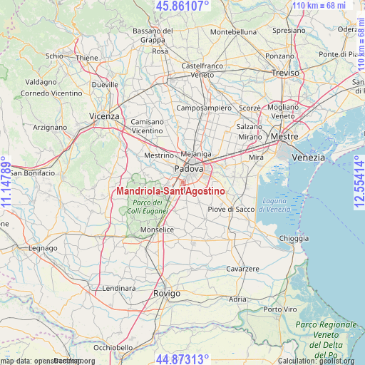
Mandriola-Sant'Agostino GPS coordinates[2]
45° 22' 9.336" North, 11° 51' 3.636" East
| Map corner | latitude | longitude |
|---|---|---|
| Upper-left | 45.86107°, | 11.14789° |
| Center: | 45.36926°, | 11.85101° |
| Lower-right: | 44.87313°, | 12.55414° |
| Map W x H: | 109.8×109.8 km | = 68.2×68.2mi |
| max Lat: | 47.04031° ⇑30.6% North |
| Mandriola-Sant'Agostino: | 45.36926° |
| min Lat: | ⇓69.4% South 35.50142° |
| min Long | Mandriola-Sant' | max Long |
| 6.69888° | 11.85101° | 18.48682° |
| W 53.8%⇐ | ⇒46.2% E |
Elevation
Elevation of Mandriola-Sant'Agostino is 9 m = 30 ft, and this is 297.7 m = 977 ft below average elevation for this country.
| Max E: |
2085 m = 6841 ft | 94.8% |
| Avg. | 306.7 m = 1006 ft | |
| Mandriola-Sant'Agostino | 9 m = 30 ft | |
Min E: |
-4 m = -13 ft | 5.2% |
See also: Italy elevation on elevation.city.
Geographical zone
Mandriola-Sant'Agostino is located in North temperate zone (between Tropic of Cancer and the Arctic Circle). Distance of this North polar circle is 2356.6 km =1464.3 mi to North.| Distance of | km | miles | from Mandriola-Sant'Agostino |
|---|---|---|---|
| North Pole | 4962.5 | 3083.6 | to North |
| Arctic Circle | 2356.6 | 1464.3 | to North |
| Tropic Cancer | 2438.7 | 1515.3 | to South |
| Equator | 5044.6 | 3134.6 | to South |


Nearby cities:
15 places around Mandriola-Sant'Agostino: (largest is in red/bold)
• Abano Terme
5.1 km =3.2 mi,  255°
255°
• Albignasego
2.8 km =1.7 mi,  152°
152°
• Bertipaglia
6.5 km =4 mi,  155°
155°
• Caselle
5.4 km =3.4 mi,  330°
330°
• Cornegliana
7.4 km =4.6 mi,  178°
178°
• Maserà di Padova
5.8 km =3.6 mi,  168°
168°
• Mezzavia
6.1 km =3.8 mi,  210°
210°
• Montegrotto Terme
6.6 km =4.1 mi,  230°
230°
• Padova
5.1 km =3.2 mi,  32°
32°
• Ponte San Nicolò
5.7 km =3.5 mi,  92°
92°
• Roncajette
7.3 km =4.5 mi,  111°
111°
• Sarmeola
6.6 km =4.1 mi,  336°
336°
• Selvazzano Dentro
5 km =3.1 mi,  294°
294°
• Tencarola
4.3 km =2.7 mi,  311°
311°
• Terradura
5.6 km =3.5 mi,  202°
202°
Sources, notices
• [Note1] Compared only with cities in Italy existing in our database
• [Src1] Map data: © OpenStreetMap contributors (CC-BY-SA)
• [Src2] Other city data from geonames.org with taken over terms of usage.
• [Src3] Geographical zone / Annual Mean Temperature by Robert A. Rohde @ Wikipedia
