Albanella geodata
Albanella (Campania) is a seat of a third-order administrative division; located in Italy in Europe/Rome (GMT+2) time zone. With population of 1,488 people, there are 5142 cities with bigger population in this country. Compared to other cities in Italy, 84.2% of cities are located further ↑North; 88.1% of cities are located further ←West and 51.8% of cities have higher elevation than Albanella. Note1


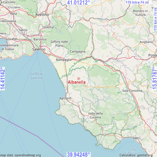
Albanella GPS coordinates[2]
40° 28' 45.948" North, 15° 6' 52.344" East
| Map corner | latitude | longitude |
|---|---|---|
| Upper-left | 41.01212°, | 14.41142° |
| Center: | 40.47943°, | 15.11454° |
| Lower-right: | 39.94248°, | 15.81767° |
| Map W x H: | 118.9×118.9 km | = 73.9×73.9mi |
| max Lat: | 47.04031° ⇑84.2% North |
| Albanella: | 40.47943° |
| min Lat: | ⇓15.8% South 35.50142° |
| min Long | Albanella | max Long |
| 6.69888° | 15.11454° | 18.48682° |
| W 88.1%⇐ | ⇒11.9% E |
Elevation
Elevation of Albanella is 223 m = 732 ft, and this is 83.7 m = 275 ft below average elevation for this country.
| Max E: |
2085 m = 6841 ft | 51.8% |
| Avg. | 306.7 m = 1006 ft | |
| Albanella | 223 m = 732 ft | |
Min E: |
-4 m = -13 ft | 48.2% |
See also: Italy elevation on elevation.city.
Geographical zone
Albanella is located in North temperate zone (between Tropic of Cancer and the Arctic Circle). Distance of this Northern Tropic circle is 1895 km =1177.5 mi to South.| Distance of | km | miles | from Albanella |
|---|---|---|---|
| North Pole | 5506.2 | 3421.4 | to North |
| Arctic Circle | 2900.3 | 1802.2 | to North |
| Tropic Cancer | 1895 | 1177.5 | to South |
| Equator | 4500.9 | 2796.7 | to South |


Nearby cities:
15 places around Albanella: (largest is in red/bold)
• Altavilla Silentina
5.8 km =3.6 mi,  14°
14°
• Bivio Santa Cecilia
10.8 km =6.7 mi,  296°
296°
• Borgo Carillia
7.4 km =4.6 mi,  323°
323°
• Cafasso-Borgo Nuovo
9.9 km =6.2 mi,  242°
242°
• Capaccio
6.8 km =4.2 mi,  205°
205°
• Capaccio Scalo
9.3 km =5.8 mi,  253°
253°
• Castelcivita
10.2 km =6.3 mi,  81°
81°
• Cerrelli
5.5 km =3.4 mi,  351°
351°
• Controne
8.3 km =5.2 mi,  65°
65°
• Giungano
9.5 km =5.9 mi,  183°
183°
• Matinella
4.7 km =2.9 mi, 301°
• Ponte Barizzo
8.3 km =5.2 mi,  280°
280°
• Rettifilo-Vannullo
8 km =5 mi, 246°
• Roccadaspide
9 km =5.6 mi,  133°
133°
• Trentinara
8.8 km =5.5 mi, 179°
Sources, notices
• [Note1] Compared only with cities in Italy existing in our database
• [Src1] Map data: © OpenStreetMap contributors (CC-BY-SA)
• [Src2] Other city data from geonames.org with taken over terms of usage.
• [Src3] Geographical zone / Annual Mean Temperature by Robert A. Rohde @ Wikipedia
