Giungano geodata
Giungano (Campania) is a seat of a third-order administrative division; located in Italy in Europe/Rome (GMT+2) time zone. With population of 399 people, there are 10286 cities with bigger population in this country. Compared to other cities in Italy, 84.8% of cities are located further ↑North; 88.1% of cities are located further ←West and 50.4% of cities have higher elevation than Giungano. Note1


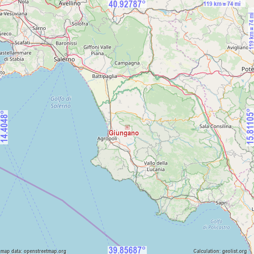
Giungano GPS coordinates[2]
40° 23' 40.2" North, 15° 6' 28.512" East
| Map corner | latitude | longitude |
|---|---|---|
| Upper-left | 40.92787°, | 14.4048° |
| Center: | 40.3945°, | 15.10792° |
| Lower-right: | 39.85687°, | 15.81105° |
| Map W x H: | 119.1×119.1 km | = 74×74mi |
| max Lat: | 47.04031° ⇑84.8% North |
| Giungano: | 40.3945° |
| min Lat: | ⇓15.2% South 35.50142° |
| min Long | Giungano | max Long |
| 6.69888° | 15.10792° | 18.48682° |
| W 88.1%⇐ | ⇒11.9% E |
Elevation
Elevation of Giungano is 232 m = 761 ft, and this is 74.7 m = 245 ft below average elevation for this country.
| Max E: |
2085 m = 6841 ft | 50.4% |
| Avg. | 306.7 m = 1006 ft | |
| Giungano | 232 m = 761 ft | |
Min E: |
-4 m = -13 ft | 49.6% |
See also: Italy elevation on elevation.city.
Geographical zone
Giungano is located in North temperate zone (between Tropic of Cancer and the Arctic Circle). Distance of this Northern Tropic circle is 1885.5 km =1171.6 mi to South.| Distance of | km | miles | from Giungano |
|---|---|---|---|
| North Pole | 5515.6 | 3427.2 | to North |
| Arctic Circle | 2909.7 | 1808 | to North |
| Tropic Cancer | 1885.5 | 1171.6 | to South |
| Equator | 4491.4 | 2790.8 | to South |


Nearby cities:
15 places around Giungano: (largest is in red/bold)
• Albanella
9.5 km =5.9 mi,  3°
3°
• Cafasso-Borgo Nuovo
9.5 km =5.9 mi,  300°
300°
• Capaccio
4.1 km =2.5 mi,  324°
324°
• Cicerale
5.9 km =3.7 mi,  161°
161°
• Copersito
9.7 km =6 mi,  203°
203°
• Licinella-Torre di Paestum
9.4 km =5.8 mi,  278°
278°
• Mattine
7.1 km =4.4 mi,  262°
262°
• Monteforte Cilento
8.1 km =5 mi,  114°
114°
• Ogliastro Cilento
7.1 km =4.4 mi,  227°
227°
• Prignano Cilento
7.6 km =4.7 mi,  206°
206°
• Rettifilo-Vannullo
9.3 km =5.8 mi,  312°
312°
• Roccadaspide
7.7 km =4.8 mi,  65°
65°
• Santa Venere
8.3 km =5.2 mi, 282°
• Torchiara
9.3 km =5.8 mi, 209°
• Trentinara
0.9 km =0.6 mi,  46°
46°
Sources, notices
• [Note1] Compared only with cities in Italy existing in our database
• [Src1] Map data: © OpenStreetMap contributors (CC-BY-SA)
• [Src2] Other city data from geonames.org with taken over terms of usage.
• [Src3] Geographical zone / Annual Mean Temperature by Robert A. Rohde @ Wikipedia
