Calolziocorte geodata
Calolziocorte (Lombardy) is a seat of a third-order administrative division; located in Italy in Europe/Rome (GMT+2) time zone. With population of 13,794 people, there are 657 cities with bigger population in this country. Compared to other cities in Italy, 85.6% of cities are located further ↓South; 74% of cities are located further →East and 51.4% of cities have higher elevation than Calolziocorte. Note1


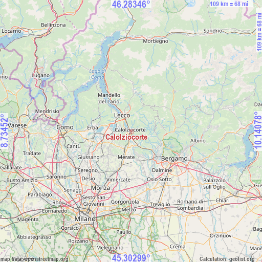
Calolziocorte GPS coordinates[2]
45° 47' 43.368" North, 9° 26' 15.54" East
| Map corner | latitude | longitude |
|---|---|---|
| Upper-left | 46.28346°, | 8.73452° |
| Center: | 45.79538°, | 9.43765° |
| Lower-right: | 45.30299°, | 10.14078° |
| Map W x H: | 109×109 km | = 67.7×67.7mi |
| max Lat: | 47.04031° ⇑14.4% North |
| Calolziocorte: | 45.79538° |
| min Lat: | ⇓85.6% South 35.50142° |
| min Long | Calolziocorte | max Long |
| 6.69888° | 9.43765° | 18.48682° |
| W 26%⇐ | ⇒74% E |
Elevation
Elevation of Calolziocorte is 225 m = 738 ft, and this is 81.7 m = 268 ft below average elevation for this country.
| Max E: |
2085 m = 6841 ft | 51.4% |
| Avg. | 306.7 m = 1006 ft | |
| Calolziocorte | 225 m = 738 ft | |
Min E: |
-4 m = -13 ft | 48.6% |
See also: Italy elevation on elevation.city.
Geographical zone
Calolziocorte is located in North temperate zone (between Tropic of Cancer and the Arctic Circle). Distance of this North polar circle is 2309.2 km =1434.9 mi to North.| Distance of | km | miles | from Calolziocorte |
|---|---|---|---|
| North Pole | 4915.1 | 3054.1 | to North |
| Arctic Circle | 2309.2 | 1434.9 | to North |
| Tropic Cancer | 2486 | 1544.7 | to South |
| Equator | 5092 | 3164 | to South |


Nearby cities:
15 places around Calolziocorte: (largest is in red/bold)
• Airuno
4.7 km =2.9 mi,  189°
189°
• Carenno
2.1 km =1.3 mi,  70°
70°
• Costa Valle Imagna
5.2 km =3.2 mi,  80°
80°
• Erve
3.1 km =1.9 mi,  22°
22°
• Favirano
2 km =1.2 mi,  138°
138°
• Galbiate
5.1 km =3.2 mi,  297°
297°
• Garlate
3.5 km =2.2 mi, 302°
• Monte Marenzo
2.9 km =1.8 mi,  152°
152°
• Olginate
1.5 km =0.9 mi,  252°
252°
• Pescate
5.4 km =3.4 mi,  321°
321°
• Sant'Antonio
5.6 km =3.5 mi, 139°
• Torre de' Busi
4.1 km =2.5 mi,  125°
125°
• Valgreghentino
2.6 km =1.6 mi,  226°
226°
• Vercurago
2 km =1.2 mi, 322°
• Vergano-Villa
4.9 km =3 mi,  268°
268°
Sources, notices
• [Note1] Compared only with cities in Italy existing in our database
• [Src1] Map data: © OpenStreetMap contributors (CC-BY-SA)
• [Src2] Other city data from geonames.org with taken over terms of usage.
• [Src3] Geographical zone / Annual Mean Temperature by Robert A. Rohde @ Wikipedia
