Sega geodata
Sega (Veneto) is a populated place; located in Italy in Europe/Rome (GMT+2) time zone. With population of 966 people, there are 6789 cities with bigger population in this country. Compared to other cities in Italy, 74.3% of cities are located further ↓South; 59.7% of cities are located further →East and 70.9% of cities have higher elevation than Sega. Note1


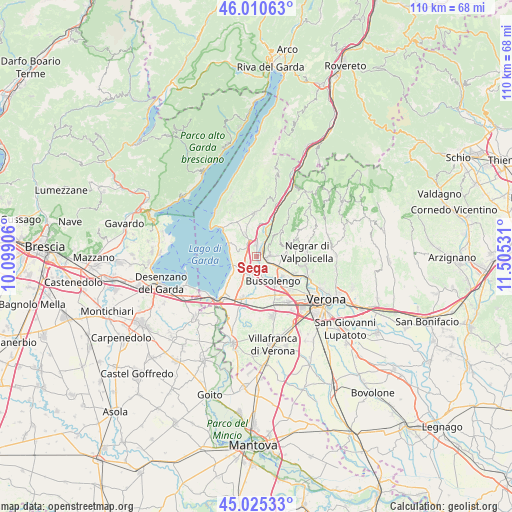
Sega GPS coordinates[2]
45° 31' 12.504" North, 10° 48' 7.848" East
| Map corner | latitude | longitude |
|---|---|---|
| Upper-left | 46.01063°, | 10.09906° |
| Center: | 45.52014°, | 10.80218° |
| Lower-right: | 45.02533°, | 11.50531° |
| Map W x H: | 109.6×109.6 km | = 68.1×68.1mi |
| max Lat: | 47.04031° ⇑25.7% North |
| Sega: | 45.52014° |
| min Lat: | ⇓74.3% South 35.50142° |
| min Long | Sega | max Long |
| 6.69888° | 10.80218° | 18.48682° |
| W 40.3%⇐ | ⇒59.7% E |
Elevation
Elevation of Sega is 93 m = 305 ft, and this is 213.7 m = 701 ft below average elevation for this country.
| Max E: |
2085 m = 6841 ft | 70.9% |
| Avg. | 306.7 m = 1006 ft | |
| Sega | 93 m = 305 ft | |
Min E: |
-4 m = -13 ft | 29.1% |
See also: Italy elevation on elevation.city.
Geographical zone
Sega is located in North temperate zone (between Tropic of Cancer and the Arctic Circle). Distance of this North polar circle is 2339.8 km =1453.9 mi to North.| Distance of | km | miles | from Sega |
|---|---|---|---|
| North Pole | 4945.7 | 3073.1 | to North |
| Arctic Circle | 2339.8 | 1453.9 | to North |
| Tropic Cancer | 2455.4 | 1525.7 | to South |
| Equator | 5061.4 | 3145 | to South |


Nearby cities:
15 places around Sega: (largest is in red/bold)
• Affi
3.9 km =2.4 mi,  341°
341°
• Bardolino
5.9 km =3.7 mi,  293°
293°
• Bure
5.4 km =3.4 mi,  82°
82°
• Calmasino
3.9 km =2.4 mi,  271°
271°
• Cavajon Veronese
3.3 km =2.1 mi,  311°
311°
• Lazise
5.2 km =3.2 mi,  251°
251°
• Ospedaletto
3.6 km =2.2 mi,  119°
119°
• Pastrengo
2.7 km =1.7 mi,  185°
185°
• Pescantina
6.4 km =4 mi,  126°
126°
• Rivoli Veronese
5.9 km =3.7 mi,  7°
7°
• San Pietro in Cariano
6.6 km =4.1 mi,  92°
92°
• Sant'Ambrogio di Valpollicella
2.7 km =1.7 mi, 88°
• Santa Lucia
2.6 km =1.6 mi,  141°
141°
• Via Pastrengo
5.3 km =3.3 mi,  156°
156°
• Volargne
2.2 km =1.4 mi,  33°
33°
Sources, notices
• [Note1] Compared only with cities in Italy existing in our database
• [Src1] Map data: © OpenStreetMap contributors (CC-BY-SA)
• [Src2] Other city data from geonames.org with taken over terms of usage.
• [Src3] Geographical zone / Annual Mean Temperature by Robert A. Rohde @ Wikipedia
