Fiumana geodata
Fiumana (Emilia-Romagna) is a populated place; located in Italy in Europe/Rome (GMT+2) time zone. With population of 1,647 people, there are 4791 cities with bigger population in this country. Compared to other cities in Italy, 53.3% of cities are located further ↑North; 55.7% of cities are located further ←West and 74.7% of cities have higher elevation than Fiumana. Note1
Administrative division(s):
- Level 1: Emilia-Romagna
- Level 2: Provincia di Forlì-Cesena
- Level 3: Predappio


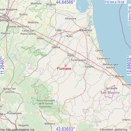
Fiumana GPS coordinates[2]
44° 8' 35.7" North, 11° 59' 13.884" East
| Map corner | latitude | longitude |
|---|---|---|
| Upper-left | 44.64566°, | 11.28407° |
| Center: | 44.14325°, | 11.98719° |
| Lower-right: | 43.63653°, | 12.69032° |
| Map W x H: | 112.2×112.2 km | = 69.7×69.7mi |
| max Lat: | 47.04031° ⇑53.3% North |
| Fiumana: | 44.14325° |
| min Lat: | ⇓46.7% South 35.50142° |
| min Long | Fiumana | max Long |
| 6.69888° | 11.98719° | 18.48682° |
| W 55.7%⇐ | ⇒44.3% E |
Elevation
Elevation of Fiumana is 75 m = 246 ft, and this is 231.7 m = 760 ft below average elevation for this country.
| Max E: |
2085 m = 6841 ft | 74.7% |
| Avg. | 306.7 m = 1006 ft | |
| Fiumana | 75 m = 246 ft | |
Min E: |
-4 m = -13 ft | 25.3% |
See also: Italy elevation on elevation.city.
Geographical zone
Fiumana is located in North temperate zone (between Tropic of Cancer and the Arctic Circle). Distance of this Northern Tropic circle is 2302.4 km =1430.6 mi to South.| Distance of | km | miles | from Fiumana |
|---|---|---|---|
| North Pole | 5098.8 | 3168.2 | to North |
| Arctic Circle | 2492.9 | 1549 | to North |
| Tropic Cancer | 2302.4 | 1430.6 | to South |
| Equator | 4908.3 | 3049.9 | to South |


Nearby cities:
15 places around Fiumana: (largest is in red/bold)
• Bertinoro
11.9 km =7.4 mi,  87°
87°
• Carpena
7.7 km =4.8 mi,  52°
52°
• Castrocaro Terme
4.7 km =2.9 mi,  320°
320°
• Castrocaro Terme e Terra del Sole
5.3 km =3.3 mi,  336°
336°
• Cusercoli
11 km =6.8 mi,  171°
171°
• Dovadola
8.3 km =5.2 mi,  253°
253°
• Forlimpopoli
12.5 km =7.8 mi,  64°
64°
• Forlì
9.7 km =6 mi,  26°
26°
• Fratta Terme
9.2 km =5.7 mi, 91°
• Meldola
6.3 km =3.9 mi,  105°
105°
• Predappio
4.5 km =2.8 mi,  183°
183°
• San Colombano
7.1 km =4.4 mi,  135°
135°
• San Lorenzo in Noceto
2.5 km =1.6 mi,  37°
37°
• Selbagnone
10.3 km =6.4 mi,  70°
70°
• Villanova
11.6 km =7.2 mi,  357°
357°
Sources, notices
• [Note1] Compared only with cities in Italy existing in our database
• [Src1] Map data: © OpenStreetMap contributors (CC-BY-SA)
• [Src2] Other city data from geonames.org with taken over terms of usage.
• [Src3] Geographical zone / Annual Mean Temperature by Robert A. Rohde @ Wikipedia
